Liste der Einträge im National Register of Historic Places im Macoupin County
Die Liste der Einträge im National Register of Historic Places im Macoupin County in Illinois führt alle acht Bauwerke und historischen Stätten im Macoupin County auf, die in das National Register of Historic Places aufgenommen wurden.[1]
Legende
| NRHP | Historic Place |
|---|---|
| HD | Historic District |
Aktuelle Einträge
| [2] | Name[3] | Bild | Eintragsdatum | Lage | Ort | Beschreibung |
|---|---|---|---|---|---|---|
| 1 | John C. Anderson House |  John C. Anderson House |
1992 ID-Nr. 92001535 |
920 West Breckenridge Street 39° 17′ 28″ N, 89° 53′ 11″ W |
Carlinville | |
| 2 | Carlinville Chapter House |  Carlinville Chapter House |
1980 ID-Nr. 80001385 |
111 South Charles Street 39° 17′ 52″ N, 89° 52′ 32″ W |
Carlinville | |
| 3 | Carlinville Historic District |  Carlinville Historic District |
1976 ID-Nr. 76000721 |
Abgegrenzt durch Oak Street, Mulberry Street, Morgan Street und die östliche Stadtgrenze 39° 16′ 46″ N, 89° 52′ 17″ W |
Carlinville | |
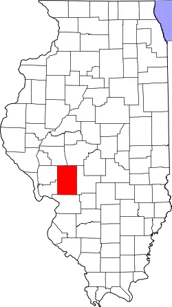
| 4 | J. L. Robinson General Store |  J. L. Robinson General Store |
1980 ID-Nr. 80001386 |
Abseits der IL 108 39° 18′ 15,1″ N, 90° 4′ 44,9″ W |
Hagaman | |
| 5 | Route 66, Girard to Nilwood |  Route 66, Girard to Nilwood |
2002 ID-Nr. 99000117 |
Ehemalige Route 66 auf der heutigen IL 4 von Girard nach Nilwood 39° 25′ 16″ N, 89° 47′ 31,6″ W |
Zwischen Girard und Nilwood | |
| 6 | Shriver Farmstead | 1980 ID-Nr. 80001387 |
Nordwestlich von Virden 39° 31′ 20″ N, 89° 48′ 47″ W |
Virden | ||
| 7 | Soulsby Service Station | 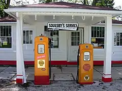 Soulsby Service Station |
2004 ID-Nr. 04000420 |
102 South Route 66 Street 39° 4′ 23″ N, 89° 44′ 8″ W |
Mount Olive | |
| 8 | Union Miners Cemetery |  Union Miners Cemetery |
1972 ID-Nr. 72000463 |
800 m nördlich des Mount Olive City Park 39° 4′ 52″ N, 89° 43′ 53″ W |
Mount Olive |
Siehe auch
Weblinks
Einzelnachweise
- Auszug aus dem National Register of Historic Places – Macoupin County Abgerufen am 20. Juli 2012
- Die Nummerierung in dieser Listenspalte ist an der vom National Park Service vorgelegten Reihenfolge der Einträge orientiert; die Farben unterscheiden verschiedene Schutzgebietstypen des National Park Systems mit landesweiter Bedeutung (z. B. National Historic Landmarks) von den sonstigen Einträgen im National Register of Historic Places.
- National Register Information System. In: National Register of Historic Places. National Park Service. Abgerufen am 9. Juli 2010.

National Register of Historic Places in Illinois
Adams | Alexander | Bond | Boone | Brown | Bureau | Calhoun | Carroll | Cass | Champaign | Christian | Clark | Clay | Clinton | Coles | Cook (inkl. Chicago) | Crawford | Cumberland | DeKalb | DeWitt | Douglas | DuPage | Edgar | Edwards | Effingham | Fayette | Ford | Franklin | Fulton | Gallatin | Greene | Grundy | Hamilton | Hancock | Hardin | Henderson | Henry | Iroquois | Jackson | Jasper | Jefferson | Jersey | Jo Daviess | Johnson | Kane | Kankakee | Kendall | Knox | LaSalle | Lake | Lawrence | Lee | Livingston | Logan | Macon | Macoupin | Madison | Marion | Marshall | Mason | Massac | McDonough | McHenry | McLean | Menard | Mercer | Monroe | Montgomery | Morgan | Moultrie | Ogle | Peoria | Perry | Piatt | Pike | Pope | Pulaski | Putnam | Randolph | Richland | Rock Island | Saline | Sangamon | Schuyler | Scott | Shelby | St. Clair | Stark | Stephenson | Tazewell | Union | Vermilion | Wabash | Warren | Washington | Wayne | White | Whiteside | Will | Williamson | Winnebago | Woodford