Lehota pod Vtáčnikom
Lehota pod Vtáčnikom ist eine Gemeinde in der Slowakei.
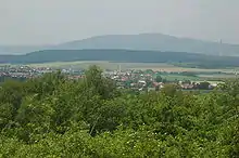
Blick auf den Ort
| Lehota pod Vtáčnikom | |||
|---|---|---|---|
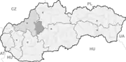
| Wappen | Karte | ||
 |
| ||
| Basisdaten | |||
| Staat: | Slowakei | ||
| Kraj: | Trenčiansky kraj | ||
| Okres: | Prievidza | ||
| Region: | Horná Nitra | ||
| Fläche: | 27,97 km² | ||
| Einwohner: | 3.843 (31. Dez. 2020) | ||
| Bevölkerungsdichte: | 137 Einwohner je km² | ||
| Höhe: | 397 m n.m. | ||
| Postleitzahl: | 972 42 | ||
| Telefonvorwahl: | 0 46 | ||
| Geographische Lage: | 48° 42′ N, 18° 36′ O | ||
| Kfz-Kennzeichen: | PD | ||
| Kód obce: | 514136 | ||
| Struktur | |||
| Gemeindeart: | Gemeinde | ||
| Gliederung Gemeindegebiet: | 2 Gemeindeteile | ||
| Verwaltung (Stand: November 2018) | |||
| Bürgermeister: | Ján Daňo | ||
| Adresse: | Obecný úrad Lehota pod Vtáčnikom Námestie SNP 33/1 97242 Lehota pod Vtáčnikom | ||
| Webpräsenz: | www.lehotapodvtacnikom.sk | ||
| Statistikinformation auf statistics.sk | |||
Sie entstand 1960 durch den Zusammenschluss der Gemeinden Malá Lehota (deutsch Klein-Lehotta, ungarisch Kispapszabadi) und Veľká Lehota (deutsch Groß-Lehotta, ungarisch Istvánszabadja).
Weblinks
Commons: Lehota pod Vtáčnikom – Sammlung von Bildern, Videos und Audiodateien
This article is issued from Wikipedia. The text is licensed under Creative Commons - Attribution - Sharealike. The authors of the article are listed here. Additional terms may apply for the media files, click on images to show image meta data.