Kotamobagu
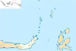
Kotamobagu ist eine Stadt in der indonesischen Provinz Sulawesi Utara auf der Insel Sulawesi. Kotamobagu hat seit dem 2. Januar 2007 den Status einer administrativ direkt der Provinz unterstellten Stadt (Kota).
| Kota Kotamobagu Kotamobagu | |||
|---|---|---|---|
| |||
| Koordinaten | 0° 44′ N, 124° 19′ O | ||
 | |||
| Symbole | |||
| |||
| Basisdaten | |||
| Staat | Indonesien | ||
|
Geographische Einheit |
Sulawesi | ||
| Provinz | Sulawesi Utara | ||
| Fläche | 184,3 km² | ||
| Einwohner | 107.459 (2010) | ||
| Dichte | 583 Ew./km² | ||
| Website | www.kotamobagukota.go.id (indonesisch) | ||
| Politik | |||
| Bürgermeister | Ir. Hj. Tatong Bara | ||
Die Einwohnerzahl am Ende des Jahres 2010 belief sich auf 107.459 Einwohner.[1]
Verwaltungsgliederung
Kotamobagu besteht aus vier Distrikten (Kecamatan) und 33 Untereinheiten (Kelurahan).[2]
| Distrikt | Deutscher Name | Bevölkerung Zensus 2010 |
|---|---|---|
| Kotamobagu Selatan | (Süd Kotamobagu) | 28.030 |
| Kotamobagu Timur | (Ost Kotamobagu) | 26.355 |
| Kotamobagu Barat | (West Kotamobagu) | 37.678 |
| Kotamobagu Utara | (Nord Kotamobagu) | 15.396 |
Einzelnachweise
- Jumlah Penduduk Sulawesi Utara Tahun 2010 (Memento des Originals vom 28. November 2011 im Internet Archive) Info: Der Archivlink wurde automatisch eingesetzt und noch nicht geprüft. Bitte prüfe Original- und Archivlink gemäß Anleitung und entferne dann diesen Hinweis.
- Biro Pusat Statistik, Jakarta, 2011.
This article is issued from Wikipedia. The text is licensed under Creative Commons - Attribution - Sharealike. The authors of the article are listed here. Additional terms may apply for the media files, click on images to show image meta data.

