Kanton Saint-Cloud
Der Kanton Saint-Cloud ist ein französischer Wahlkreis in den Arrondissements Boulogne-Billancourt und Nanterre, im Département Hauts-de-Seine und in der Region Île-de-France; sein Hauptort ist Saint-Cloud. Vertreter im Generalrat des Départements ist seit 2011 Éric Berdoati (UMP).
| Kanton Saint-Cloud | |
|---|---|
| Region | Île-de-France |
| Département | Hauts-de-Seine |
| Arrondissement | Boulogne-Billancourt Nanterre |
| Hauptort | Saint-Cloud |
| Einwohner | 69.489 (1. Jan. 2019) |
| Bevölkerungsdichte | 3.391 Einw./km² |
| Fläche | 20,49 km² |
| Gemeinden | 5 |
| INSEE-Code | 9223 |
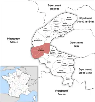 Lage des Kantons Saint-Cloud im Département Hauts-de-Seine | |
Gemeinden
Der Kanton besteht aus fünf Gemeinden mit insgesamt 69.489 Einwohnern (Stand: 1. Januar 2019) auf einer Gesamtfläche von 20,49 km²:
| Gemeinde | Einwohner 1. Januar 2019 |
Fläche km² |
Dichte Einw./km² |
Code INSEE |
Postleitzahl | Arrondissement |
|---|---|---|---|---|---|---|
| Garches | 17.795 | 2,71 | 6.566 | 92033 | 92380 | Nanterre |
| Marnes-la-Coquette | 1.774 | 3,48 | 510 | 92047 | 92430 | Boulogne-Billancourt |
| Saint-Cloud | 30.012 | 7,52 | 3.991 | 92064 | 92210 | Nanterre |
| Vaucresson | 8.683 | 3,09 | 2.810 | 92076 | 92420 | Nanterre |
| Ville-d’Avray | 11.225 | 3,69 | 3.042 | 92077 | 92410 | Boulogne-Billancourt |
| Kanton Saint-Cloud | 69.489 | 20,49 | 3.391 | 9223 | – | – |
Bis zur Neuordnung bestand der Kanton Saint-Cloud aus der Gemeinde Saint-Cloud. Sein Zuschnitt entsprach einer Fläche von 7,56 km2.
Bevölkerungsentwicklung
| 1962 | 1968 | 1975 | 1982 | 1990 | 1999 | 2008 |
|---|---|---|---|---|---|---|
| 26 472 | 28 158 | 28 139 | 28 561 | 28 597 | 28 157 | 29 772 |
This article is issued from Wikipedia. The text is licensed under Creative Commons - Attribution - Sharealike. The authors of the article are listed here. Additional terms may apply for the media files, click on images to show image meta data.