Distrikt Kisoro
Kisoro ist ein Distrikt in Westuganda. Die Hauptstadt des Distrikts ist Kisoro.
| Karte | |
|---|---|
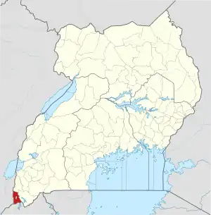
 Lage von Kisoro | |
| Basisdaten | |
| Hauptstadt | Kisoro |
| Geographisches Zentrum | 1° 17′ N, 29° 41′ O |
| Fläche | 728 km² |
| Einwohnerzahl | 315.400 (Stand 2020) |
| Bevölkerungsdichte | 433,2 Einwohner/km² |
| Zeitzone | UTC +3 |
Lage
Der Distrikt Kisoro befindet sich im äußersten Südwesten Ugandas und grenzt im Norden an den Distrikt Kanungu, im Osten an den Distrikt Kabale, im Süden an Ruanda und im Westen an die Demokratische Republik Kongo.
Demografie
Die Bevölkerungszahl wird für 2020 auf 315.400 geschätzt. Davon lebten im selben Jahr 6,4 Prozent in städtischen Regionen und 93,6 Prozent in ländlichen Regionen.[1]
| Zensusjahr | Einwohnerzahl |
|---|---|
| 1991 | 186.681 |
| 2002 | 220.312 |
| 2014 | 281.705 |
Wirtschaft
Die lokale Wirtschaft wird von der Landwirtschaft dominiert.
Naturschutzgebiete
Der Bwindi Impenetrable National Park und Mgahinga-Gorilla-Nationalpark befinden sich in dem Distrikt.
Einzelnachweise
- Kisoro (Bezirk, Uganda) - Einwohnerzahlen, Grafiken, Karte und Lage. Abgerufen am 5. Juli 2020.
This article is issued from Wikipedia. The text is licensed under Creative Commons - Attribution - Sharealike. The authors of the article are listed here. Additional terms may apply for the media files, click on images to show image meta data.