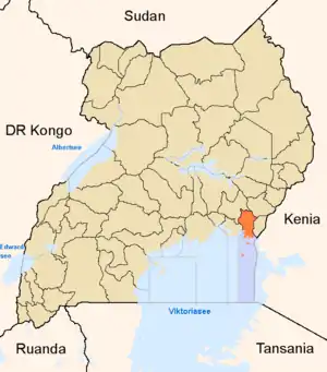
Distrikt Bugiri
Bugiri ist ein Distrikt (district) in Ost-Uganda am Ufer des Viktoriasees mit etwa 480,400 Einwohnern[1] und einer gesamten Fläche von 1.607 Quadratkilometern, die sich aus 962 km² Landfläche und 735 km² Wasserfläche zusammensetzt.[2] Wie fast alle Distrikte von Uganda ist er nach seinem Hauptort benannt.
| Karte | |
|---|---|
 Lage von Bugiri | |
| Basisdaten | |
| Hauptstadt | Bugiri |
| Geographisches Zentrum | 0° 12′ S, 33° 47′ O |
| Nord-Süd-Ausdehnung | 188 km |
| Ost-West-Ausdehnung | 40 km |
| Fläche | 1.607 km² |
| Einwohnerzahl | 480.400 (Stand 2020) |
| Bevölkerungsdichte | 298,9 Einwohner/km² |
| Zeitzone | UTC +3 |
| ISO 3166-2 | UG-201 |
Neben dem Festland umfasst der Bugiri-Distrikt auch mehrere Inseln im Viktoriasee.
Demographie
Der Distrikt Bugiri hat 480,400 Einwohner und eine daraus resultierende Bevölkerungsdichte von 459,2 Einwohner pro km². Der Großteil der Bevölkerung mit etwa 90 % lebt in den ländlichen Gebieten, während sich der Rest auf den Hauptort Bugiri konzentriert.[3]
| Entwicklung[1] | |
|---|---|
| Censusjahr | Einwohnerzahl |
| 1991 | 171,269 |
| 2002 | 237,441 |
| 2014 | 382,913 |
| 2020 | 480,400 |
Einzelnachweise
- Uganda: Administrative Division (Regions and Districts) - Population Statistics, Charts and Map. Abgerufen am 28. Januar 2022.
- Bugiri Location Size. Abgerufen am 28. Januar 2022 (englisch).
- Bugiri (District, Uganda) - Population Statistics, Charts, Map and Location. Abgerufen am 28. Januar 2022.
This article is issued from Wikipedia. The text is licensed under Creative Commons - Attribution - Sharealike. The authors of the article are listed here. Additional terms may apply for the media files, click on images to show image meta data.