Traill County
Das Traill County[3] ist ein County im US-amerikanischen Bundesstaat North Dakota. Im Jahr 2010 hatte das County 8121 Einwohner und eine Bevölkerungsdichte von 3,6 Einwohnern pro Quadratkilometer.[4] Der Verwaltungssitz (County Seat) ist Hillsboro.[5]
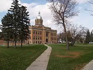 Trail County Courthouse, gelistet im NRHP mit der Nr. 80002928[2] | |
| Verwaltung | |
|---|---|
| US-Bundesstaat: | North Dakota |
| Verwaltungssitz: | Hillsboro |
| Adresse des Verwaltungssitzes: |
County Courthouse P.O. Box 429 Hillsboro, ND 58045-0429 |
| Gründung: | 1875 |
| Vorwahl: | 001 701 |
| Demographie | |
| Einwohner: | 8121 (2010) |
| Bevölkerungsdichte: | 3,64 Einwohner/km2 |
| Geographie | |
| Fläche gesamt: | 2235 km² |
| Wasserfläche: | 2 km² |
| Karte | |
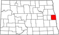 Karte von Traill County innerhalb von North Dakota | |
| Website: www.co.traill.nd.us | |
Geografie
Das County liegt im Osten von North Dakota am Westufer des Red River of the North, der die Grenze zu Minnesota bildet. Das Gelände ist sehr flach und fällt sanft zum Red River ab. Bis auf die südöstliche Ecke, die zur Drift Prairie zählt, gehört das County zum fruchtbaren Red River Valley.[6] Es hat eine Fläche von 2234 Quadratkilometern, wovon 2 Quadratkilometer Wasserfläche sind. An das Traill County grenzen folgende Nachbarcountys:
| Grand Forks County | Polk County (Minnesota) | |
| Steele County | .svg.png.webp) |
Norman County (Minnesota) |
| Cass County |
Geschichte
Das Traill County wurde 1875 von der Legislative des Dakota-Territoriums gebildet.[7] Benannt wurde es nach Walter John Strickland Traill, einem früheren Angestellten der Hudson Bay Company, der am Red River of the North einen Handelsposten erbaute.[8] Die Verwaltung des Countys wurde erst am 23. Februar 1875 gegründet, erster Sitz der Verwaltung war bis 1891 Caledonia.[7]
22 Bauwerke und Stätten des Countys sind insgesamt im National Register of Historic Places eingetragen (Stand 3. April 2018).[9]
Demografische Daten
| Bevölkerungsentwicklung | |||
|---|---|---|---|
| Census | Einwohner | ± in % | |
| 1880 | 4123 | — | |
| 1890 | 10.217 | 147,8 % | |
| 1900 | 13.107 | 28,3 % | |
| 1910 | 12.545 | −4,3 % | |
| 1920 | 12.210 | −2,7 % | |
| 1930 | 12.600 | 3,2 % | |
| 1940 | 12.300 | −2,4 % | |
| 1950 | 11.359 | −7,7 % | |
| 1960 | 10.583 | −6,8 % | |
| 1970 | 9571 | −9,6 % | |
| 1980 | 9624 | 0,6 % | |
| 1990 | 8752 | −9,1 % | |
| 2000 | 8477 | −3,1 % | |
| 2010 | 8121 | −4,2 % | |
| Schätzung 2012 | 8072 | −0,6 % | |
| Vor 1900[10] 1900–1990[11] 2000[5] 2010–2012[4] | |||
Nach der Volkszählung im Jahr 2010 lebten im Traill County 8121 Menschen in 3375 Haushalten. Die Bevölkerungsdichte betrug 3,6 Einwohner pro Quadratkilometer. In den 3375 Haushalten lebten statistisch je 2,33 Personen.
Ethnisch betrachtet setzte sich die Bevölkerung zusammen aus 96,9 Prozent Weißen, 0,5 Prozent Afroamerikanern, 0,9 Prozent amerikanischen Ureinwohnern, 0,3 Prozent Asiaten sowie aus anderen ethnischen Gruppen; 1,4 Prozent stammten von zwei oder mehr Ethnien ab. Unabhängig von der ethnischen Zugehörigkeit waren 2,7 Prozent der Bevölkerung spanischer oder lateinamerikanischer Abstammung.
22,6 Prozent der Bevölkerung waren unter 18 Jahre alt, 58,8 Prozent waren zwischen 18 und 64 und 18,6 Prozent waren 65 Jahre oder älter. 49,7 Prozent der Bevölkerung war weiblich.
Das jährliche Durchschnittseinkommen eines Haushalts lag bei 48.341 USD. Das Pro-Kopf-Einkommen betrug 24.725 USD. 8,8 Prozent der Einwohner lebten unterhalb der Armutsgrenze.[4]
Ortschaften im Traill County
Im Ramsey County liegen neun Gemeinden (City) sowie mehrere Orte ohne eigene Verwaltung, darunter auch zwei Census-designated places (CDP). Das gemeindefreie Gebiet ist in 25 Townships eingeteilt.
Gemeinden
Weitere Orte
- Alton (47° 21′ N, 97° 3′ W)[12]
- Blanchard (CDP, 47° 21′ N, 97° 13′ W)[13]
- Caledonia (CDP, ehemals Goose River, 47° 27′ N, 96° 53′ W)[14]
- Cummings (ehemals auch Cumings, 47° 31′ N, 97° 5′ W)[15]
- Greenfield (47° 16′ N, 97° 13′ W)[16]
- Kelso (47° 19′ N, 97° 2′ W)[17]
- Murray (47° 26′ N, 97° 17′ W)[18]
- Portland Junction (47° 34′ N, 97° 22′ W)[19]
- Preston (47° 19′ N, 97° 13′ W)[20]
- Roseville (47° 26′ N, 97° 23′ W)[21]
- Taft (47° 27′ N, 97° 4′ W)[22]
Townships
| Township | Einwohner (2010) |
FIPS |
|---|---|---|
| Belmont Township | 76 | 38-05940 |
| Bingham Township | 70 | 38-07060 |
| Blanchard Township | 87 | 38-07660 |
| Bloomfield Township | 130 | 38-07820 |
| Bohnsack Township | 55 | 38-08140 |
| Buxton Township | 107 | 38-11380 |
| Caledonia Township | 111 | 38-11540 |
| Eldorado Township | 107 | 38-22820 |
| Elm River Township | 32 | 38-23740 |
| Ervin Township | 160 | 38-24740 |
| Galesburg Township | 83 | 38-29020 |
| Garfield Township | 169 | 38-29300 |
| Greenfield Township | 72 | 38-33340 |
| Herberg Township | 65 | 38-37460 |
| Hillsboro Township | 132 | 38-38140 |
| Kelso Township | 69 | 38-41860 |
| Lindaas Township | 114 | 38-46860 |
| Mayville Township | 133 | 38-51540 |
| Morgan Township | 91 | 38-54380 |
| Norman Township | 74 | 38-57540 |
| Norway Township | 169 | 38-58540 |
| Roseville Township | 109 | 38-68500 |
| Stavanger Township | 110 | 38-75700 |
| Viking Township | 169 | 38-82180 |
| Wold Township | 100 | 38-87100 |
Einzelnachweise
- Auszug aus dem National Register of Historic Places Abgerufen am 13. März 2011
- Auszug aus dem National Register of Historic Places Abgerufen am 13. März 2011
- Traill County im Geographic Names Information System des United States Geological Survey
- U.S. Census Buero, State & County QuickFacts - Traill County, ND Abgerufen am 21. Juli 2013
- National Association of Counties Abgerufen am 20. Juli 2013
- John P. Bluemle: Geology and Ground Water Ressources of Traill County : Part I: Geology. 1967, S. 2 (englisch, nd.gov [PDF]).
- County History. In: nd.gov. Abgerufen am 30. August 2021 (englisch).
- Charles Curry Aiken, Joseph Nathan Kane: The American Counties: Origins of County Names, Dates of Creation, Area, and Population Data, 1950–2010. 6. Auflage. Scarecrow Press, Lanham 2013, ISBN 978-0-8108-8762-6, S. 304.
- Suchmaske Datenbank im National Register Information System. National Park Service, abgerufen am 3. April 2018.
- U.S. Census Bureau _ Census of Population and Housing Abgerufen am 17. Februar 2011
- Auszug aus Census.gov Abgerufen am 21. Februar 2011
- Alton im Geographic Names Information System des United States Geological Survey
- Blanchard im Geographic Names Information System des United States Geological Survey
- Caledonia im Geographic Names Information System des United States Geological Survey
- Cummings im Geographic Names Information System des United States Geological Survey
- Greenfield im Geographic Names Information System des United States Geological Survey
- Kelso im Geographic Names Information System des United States Geological Survey
- Murray im Geographic Names Information System des United States Geological Survey
- Portland Junction im Geographic Names Information System des United States Geological Survey
- Preston im Geographic Names Information System des United States Geological Survey
- Roseville im Geographic Names Information System des United States Geological Survey
- Taft im Geographic Names Information System des United States Geological Survey
Weblinks
Liste der Countys in North Dakota
Adams |
Barnes |
Benson |
Billings |
Bottineau |
Bowman |
Burke |
Burleigh |
Cass |
Cavalier |
Dickey |
Divide |
Dunn |
Eddy |
Emmons |
Foster |
Golden Valley |
Grand Forks |
Grant |
Griggs |
Hettinger |
Kidder |
LaMoure |
Logan |
McHenry |
McIntosh |
McKenzie |
McLean |
Mercer |
Morton |
Mountrail |
Nelson |
Oliver |
Pembina |
Pierce |
Ramsey |
Ransom |
Renville |
Richland |
Rolette |
Sargent |
Sheridan |
Sioux |
Slope |
Stark |
Steele |
Stutsman |
Towner |
Traill |
Walsh |
Ward |
Wells |
Williams