Szentegát
Szentegát ist eine ungarische Gemeinde im Kreis Szigetvár im Komitat Baranya.
| Szentegát | |||||
| |||||
| Basisdaten | |||||
|---|---|---|---|---|---|
| Staat: | Ungarn | ||||
| Region: | Südtransdanubien | ||||
| Komitat: | Baranya | ||||
| Kleingebiet bis 31.12.2012: | Szigetvár | ||||
| Kreis seit 1.1.2013: | Szigetvár | ||||
| Koordinaten: | 45° 59′ N, 17° 49′ O | ||||
| Fläche: | 12,53 km² | ||||
| Einwohner: | 420 (1. Jan. 2011) | ||||
| Bevölkerungsdichte: | 34 Einwohner je km² | ||||
| Telefonvorwahl: | (+36) 73 | ||||
| Postleitzahl: | 7915 | ||||
| KSH-kód: | 33613 | ||||
| Struktur und Verwaltung (Stand: 2020) | |||||
| Gemeindeart: | Gemeinde | ||||
| Bürgermeisterin: | Lászlóné Czifra[1] (parteilos) | ||||
| Postanschrift: | Almás utca 90/1 7915 Szentegát | ||||
| Website: | |||||
| (Quelle: A Magyar Köztársaság helységnévkönyve 2011. január 1. bei Központi statisztikai hivatal) | |||||


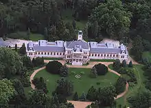
Schloss Biedermann in Szentegát
Einzelnachweise
- Helyi önkormányzati választások 2019 - Szentegát (Baranya megye). Nemzeti Választási Iroda, 13. Oktober 2019, abgerufen am 16. Juni 2020 (ungarisch).
Weblinks
Commons: Szentegát – Sammlung von Bildern, Videos und Audiodateien
- Offizielle Webseite (ungarisch)
- Szentegát bei Magyarország helységnévtára (ungarisch)
This article is issued from Wikipedia. The text is licensed under Creative Commons - Attribution - Sharealike. The authors of the article are listed here. Additional terms may apply for the media files, click on images to show image meta data.