Santa Teresita (Batangas)
Santa Teresita ist eine philippinische Stadtgemeinde in der Provinz Batangas. Sie hat 21.127 Einwohner (Zensus 1. August 2015).
| Municipality of Santa Teresita | |||
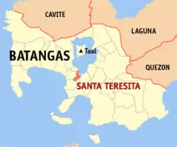
| Lage von Santa Teresita in der Provinz Batangas | |||
|---|---|---|---|
 | |||
| Basisdaten | |||
| Region: | CALABARZON | ||
| Provinz: | Batangas | ||
| Barangays: | 17 | ||
| Distrikt: | 3. Distrikt von Batangas | ||
| PSGC: | 041027000 | ||
| Einkommensklasse: | 5. Einkommensklasse | ||
| Haushalte: | 2762 Zensus 1. Mai 2000 | ||
| Einwohnerzahl: | 21.127 Zensus 1. August 2015 | ||
| Bevölkerungsdichte: | 140,8 Einwohner je km² | ||
| Fläche: | 150,03 km² | ||
| Koordinaten: | 13° 53′ N, 120° 58′ O | ||
| Postleitzahl: | 4206 | ||
| Geographische Lage auf den Philippinen | |||
| |||

Geografie
Santa Teresita liegt am südlichen Seeufer des Taal-Sees. Die Stadtgemeinde grenzt San Nicolas im Norden, San Luis im Süden, Taal im Westen und an den Taal-See im Nordosten. Die Stadtgemeinde hat eine Landfläche von 150,03 km².
Baranggays
Santa Teresita ist politisch unterteilt in 17 Baranggays, davon sind 14 als ländlich klassifiziert und 3 als städtisch.
|
|
This article is issued from Wikipedia. The text is licensed under Creative Commons - Attribution - Sharealike. The authors of the article are listed here. Additional terms may apply for the media files, click on images to show image meta data.