Parysów
Parysów ist ein Dorf sowie Sitz der gleichnamigen Landgemeinde im Powiat Garwoliński der Woiwodschaft Masowien, Polen.
| Parysów | |||
|---|---|---|---|
 |
| ||
| Basisdaten | |||
| Staat: | Polen | ||
| Woiwodschaft: | Masowien | ||
| Powiat: | Garwolin | ||
| Geographische Lage: | 51° 59′ N, 21° 41′ O | ||
| Einwohner: | 1100 (2006) | ||
| Postleitzahl: | 08-441 | ||
| Telefonvorwahl: | (+48) 25 | ||
| Kfz-Kennzeichen: | WG | ||
| Gmina | |||
| Gminatyp: | Landgemeinde | ||
| Gminagliederung: | 10 Schulzenämter | ||
| Fläche: | 64,31 km² | ||
| Einwohner: | 4143 (31. Dez. 2020)[1] | ||
| Bevölkerungsdichte: | 64 Einw./km² | ||
| Gemeindenummer (GUS): | 1403092 | ||
| Verwaltung | |||
| Adresse: | ul. Kościuszki 28 08-441 Parysów | ||
| Webpräsenz: | www.parysow.pl | ||
Verkehr
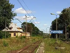
Der ehemalige Bahnhof
Der Bahnhof Parysów an der Bahnstrecke Skierniewice–Łuków ist nicht mehr in Betrieb.
Gemeinde
Zur Landgemeinde Parysów gehören folgende zehn Ortschaften mit einem Schulzenamt:
- Choiny
- Kozłów
- Łukówiec
- Parysów
- Poschła
- Słup
- Starowola
- Stodzew
- Wola Starogrodzka
- Żabieniec
Weitere Orte der Gemeinde sind Józinek und Pszonka.
Literatur
- Parysów, in: Guy Miron (Hrsg.): The Yad Vashem encyclopedia of the ghettos during the Holocaust. Jerusalem : Yad Vashem, 2009 ISBN 978-965-308-345-5, S. 577
Einzelnachweise
- Population. Size and Structure by Territorial Division. As of December 31, 2020. Główny Urząd Statystyczny (GUS) (PDF-Dateien; 0,72 MB), abgerufen am 12. Juni 2021.
This article is issued from Wikipedia. The text is licensed under Creative Commons - Attribution - Sharealike. The authors of the article are listed here. Additional terms may apply for the media files, click on images to show image meta data.