Maragondon
Maragondon (offiziell: Municipality of Maragondon; Filipino: Bayan ng Maragondon) ist eine philippinische Stadtgemeinde in der Provinz Cavite. Maragondon liegt etwa 54 km südöstlich von Manila. Sie hat 37.720 Einwohner (Zensus 1. August 2015). In der Gemeinde befindet sich ein Campus der Polytechnic University of the Philippines.
| Municipality of Maragondon Bayan ng Maragondon | |||
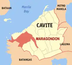
| Lage von Maragondon in der Provinz Cavite | |||
|---|---|---|---|
 | |||
| Basisdaten | |||
| Region: | CALABARZON | ||
| Provinz: | Cavite | ||
| Barangays: | 27 | ||
| Distrikt: | 3. Distrikt von Cavite | ||
| PSGC: | 042113000 | ||
| Einkommensklasse: | 4. Einkommensklasse | ||
| Haushalte: | 6282 Zensus 1. Mai 2000 | ||
| Einwohnerzahl: | 37.720 Zensus 1. August 2015 | ||
| Bevölkerungsdichte: | 186,6 Einwohner je km² | ||
| Fläche: | 202,10 km² | ||
| Koordinaten: | 14° 16′ N, 120° 44′ O | ||
| Postleitzahl: | 4112 | ||
| Bürgermeister: | Andaman A. Monte | ||
| Geographische Lage auf den Philippinen | |||
| |||

Baranggays
Maragondon ist politisch in 27 Baranggays unterteilt.
|
|
Weblinks
- Maragondon elgu2.ncc.gov.ph - Maragondon (Memento vom 2. Oktober 2007 im Internet Archive)
This article is issued from Wikipedia. The text is licensed under Creative Commons - Attribution - Sharealike. The authors of the article are listed here. Additional terms may apply for the media files, click on images to show image meta data.