Manantali-See
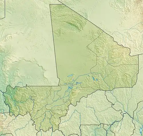
Der Manantali-See (franz.: Lac Manantali) ist ein Stausee in der Region Kayes, im südwestlichen Mali.
| Manantali-See Lac Manantali | |||||||||
|---|---|---|---|---|---|---|---|---|---|
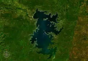 Satellitenbild des Manantali-Sees | |||||||||
| |||||||||
| |||||||||
| Koordinaten | 13° 5′ 47″ N, 10° 21′ 32″ W | ||||||||
| Daten zum Bauwerk | |||||||||
| Daten zum Stausee | |||||||||
| Wasseroberfläche | 477 km² | ||||||||
Beschreibung
Der 477 km² große See im Dreiländereck Mauretanien, Mali und Senegal wird durch den Bafing gespeist, der auch durch ihn abfließt. Er entstand 1989 durch die ab 1982 gebaute, im Wesentlichen von Deutschland, Frankreich, den USA und Saudi-Arabien finanzierte Manantali-Talsperre.[1]
Bafoulabé ist die nächstgelegene Stadt.
Literatur
- V.R.Southgate: Schistosomiasis in the Senegal River Basin: before and after the construction of the dams at Diama, Senegal and Manantali, Mali and future prospects. Journal of Helminthology, Volume 71, Issue 2, Juni 1997, Seite 125–132. doi:10.1017/S0022149X00015790
Einzelnachweise
- Louise Fox: Attacking Africa’s Poverty: Experience from the Ground.
This article is issued from Wikipedia. The text is licensed under Creative Commons - Attribution - Sharealike. The authors of the article are listed here. Additional terms may apply for the media files, click on images to show image meta data.