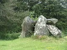
Liste der Portal Tombs in Irland
Die Liste der Portal Tombs in Irland enthält alle Portal Tombs in der Republik Irland und in Nordirland, die von Seán Ó Nualláin[1] beschrieben sind. Zusätzlich werden
zwischenzeitlich entdeckte oder als solche eingestufte Dolmen aufgelistet. Für diese wurden die folgenden Quellen benutzt:
Erhaltene Portal Tombs
County: Antrim Armagh Carlow Cavan Clare Cork Derry Donegal Down Dublin Fermanagh Galway Kerry Kilkenny Leitrim Longford Louth Mayo Meath Monaghan Roscommon Sligo Tipperary Tyrone Waterford Wexford Wicklow
Im Gaeltacht sind die Namen der Townlands auf NMS in irisch angegeben, während sie in der anderen Literatur überwiegend in englisch angegeben sind. Für das Gaeltacht werden hier beide Namen aufgeführt.
In der Spalte Lage/ SMR werden die Geodaten, angegeben:
- Oben die Koordinaten in internationaler Schreibweise im dezimalen Graden (am besten kopierbar)
- darunter die Werte des Irish Grid des Ordnance Survey Ireland (OSI)
- darunter die SMR-Nummern des NMS und NISMR.
| Name (Townland) | Bekannt als | Ort | County | Bemerkung | Lage SMR |
Bild |
|---|---|---|---|---|---|---|
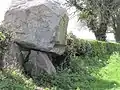
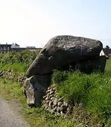
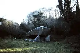
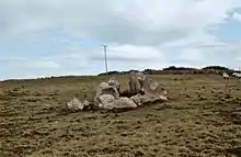
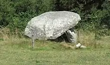
| Ballylumford | Druid’s Cottage Dolmen | Islandmagee | Antrim | Es kann sich auch um ein Passage Tomb handeln.[5] | 54,841667° N, 5,773889° W D 430 016 ANT041:007 |
Jul2007.jpg.webp) |
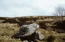
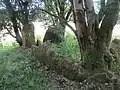
| Ballyvennaght | Cloughananca 1 | Antrim | Besitzt zwei Kammern | 55,163362° N, 6,118192° W D 202 367 ANT009:021 | ||
| Ballyvennaght | Cloughananca 2 | Antrim | 55,168381° N, 6,106028° W D 207 373 ANT009:020 |
|||
| Ballyvennaght | Antrim | 55,160173° N, 6,105019° W D 208 364 ANT009:022 |
||||
| Ticloy | The Stone House | Antrim | 54,938329° N, 6,079399° W D 231 117 ANT029:031 |
 | ||
| Aghmakane | Long Stones | Camlough | Armagh | 55,166153° N, 6,438306° W J 020 252 ARM025:009 |
 | |
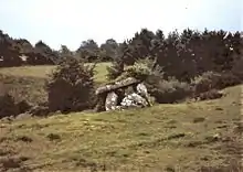
| Aughadanove | The Oul Grave | Mullaghbane | Armagh | 54,125021° N, 6,472466° W H 999 206 ARM028:004 |
||
| Aughnagurgan | Keady | Armagh | 54,198909° N, 6,667089° W H 870 285 ARM024:002 |
|||
| Ballykeel | Armagh | 54,131429° N, 6,478222° W H 995 213 ARM028:020 |
 | |||
| Clonlum | Armagh | 54,124021° N, 6,400811° W J 046 206 ARM029:005 |
 | |||
| Ballynasilloge | Borris | Carlow | 52,616732° N, 6,899354° W S 746 523 CW022-0100001 |
 | ||
| Ballygraney | Goresbridge | Carlow | 52,62° N, 6,960833° W S 704 525 CW019-090---- |
 | ||
| Ballynoe or Newtown | Carlow | 52,766753° N, 6,732625° W S 856 692 CW013-036---- |
 | |||
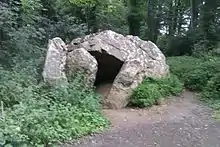
| Haroldstown | Carlow | 52,844848° N, 6,663509° W S 901 779 CW009-008---- |
.jpg.webp) | |||
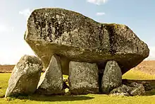
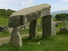
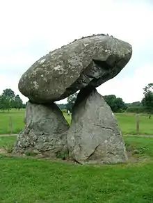
| Kernanstown | Browneshill-Dolmen | Carlow Town | Carlow | Sehr großer Deckstein | 52,837337° N, 6,881004° W S 755 768 CW007-010---- |
 |
| Kilgraney | Druid’s Altar | Goresbridge | Carlow | 52,643781° N, 6,964068° W S 702 552 CW019-041---- |
 | |
| Knockroe | Giant’s Table | Carlow | Nur auf NMS beschrieben als mögliche megal. Struktur | 52,591844° N, 6,785574° W S 822 497 CW023-012---- |
||
| Aghawee | Giant’s Grave | Cavan | 53,883528° N, 7,337139° W N 438 928 CV031-003---- |
|||
| Ballaghanea | Giant’s Grave | Virginia | Cavan | 53,824792° N, 7,052774° W N 624 866 CV039-012---- |
 | |
| Banagher | Giant’s Grave | Cavan | Gilt als eines der Kleinsten. | 53,944431° N, 7,282625° W N 471 998 CV026-006---- |
||
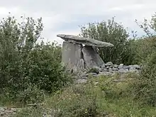
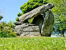
| Burren | Calfhouse | Blacklion | Cavan | 54,264722° N, 7,885° W H 076 351 CV004-004--- |
 | |
| Burren | Blacklion | Cavan | 54,263889° N, 7,883889° W H 073 345 CV004-001---- |
.jpg.webp) | ||
| Carrickacroy | Cavan | Gilt als eines der Kleinsten. | 53,870872° N, 7,302131° W N 459 915 CV032-004---- |
 | ||
| Carrickclevan | Cavan | 53,9146° N, 7,4712° W N 348 963 CV031-010---- |
||||
| Drumhawnagh | Cavan | 53,880833° N, 7,468333° W N 350 925 CV031-026---- |
 | |||
| Duffcastle | Cavan | 53,876558° N, 7,27914° W N 474 921 CV032-021---- |
 | |||
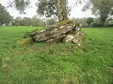
| Mayo | Cavan | 54,064412° N, 7,017068° W H 646 134 CV018-012---- |
_Portal_Tomb.jpg.webp) | |||
| Middletown | Druid’s Altar Kilcatron |
Cavan | 53,880694° N, 7,478194° W N 344 924 CV030-031---- |
|||
| Moneygashel | Cavan | 54,255058° N, 7,907549° W H 061 340 CV004-017---- |
||||
| Ballycasheen | Dermot and Grania’s Bed | Clare | 52,977472° N, 9,121194° W R 247 924 CL016-048---- |
 | ||
| Clogher | Clare | 52,869042° N, 8,674258° W R 546 800 CL035-037---- |
 | |||
| Moyree Commons | Clare | 52,949459° N, 8,948967° W R 363 891 CL018-011---- |
||||
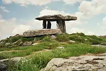
| Poulnabrone | Clare | 53,048722° N, 9,139972° W M 236 004 CL009-034001- |
 | |||
| Ahaglaslin | Roscarbery | Cork | 51,57532° N, 9,00022° W W 307 363 CO143-034---- |
|||
| Arderawinny | Cork | 51,51851° N, 9,62161° W V 875 307 CO148-011---- |
||||
| Rostellan | Midleton | Cork | Megalithomania: als Portal Tomb beschrieben. NMS: mögliche megalithische Struktur. | 51,85722° N, 8,18275° W W 875 672 CO088-010---- |
||
| Crevolea | Grey Stone | Coleraine | Derry/ Londonderry |
55,050757° N, 6,675526° W C 847 233 LDY 011:013 |
 | |
| Drumderg | Derrymore’s oder Dergmore’s Grave | Draperstown | Derry/ Londonderry |
54,805969° N, 6,833641° W H 751 959 LDY 035:002 |
 | |
| Edenreagh Beg | Giant’s Grave | Derry/ Londonderry |
Bei NISMR: Megalithic Structure | 54,994105° N, 7,191139° W C 517 166 LDY 015:028 |
||
| Ervey | Derry/ Londonderry |
54,958239° N, 7,194965° W C 516 127 LDY 023:007 |
 | |||
| Tamlaght | Cloghtogle | Croagh | Derry/ Londonderry |
liegt zur Hälfte im County Tyrone | 54,651801° N, 6,628164° W H 887 790 LDY 048:005 |
 |
| Tirnony | Maghera | Derry/ Londonderry |
54,857998° N, 6,689601° W C 841 017 LDY 036:010 |
 | ||
| Ards Beg An Ardaidh Bheag |
Dermot and Grania’s Bed | Falcarragh | Donegal | 55,122523° N, 8,158315° W B 899 306 DG024-006---- |
 | |
| Ballyannan | Buncrana | Donegal | 55,1914° N, 7,47074° W C 338 383 DG019-008---- |
|||
| Ballymore Lower | Creeslough | Donegal | Auf Megalithomania als Portal Tomb beschrieben. Auf NMS: „unclassified“ | 55,159722° N, 7,921944° W C 050 347 DG026-003---- |
||
| Bin | Donegal | Gilt als eines der kleinsten. | 55,13676° N, 7,53615° W C 297 322 DG028-019---- |
|||
| Carnaghan | Inch Island | Donegal | 55,059632° N, 7,499979° W C 320 238 DG037-019001- |
|||
| Carrickmagrath/Meenbog | Ballybofey | Donegal | Nur auf NMS beschrieben. | 54,764673° N, 7,82769° W C 113 907 SMR: DG077-021--- |
||
| Claggan | Horn Head | Donegal | 55,209883° N, 8,010923° W B 993 403 DG015-004---- |
|||
| Cloghroe | Drumkeen | Donegal | 54,853694° N, 7,791361° W DL C 134 008 DG069-018---- |
 | ||
| Errarooey Beg Oirear Dhumhaí Beag |
Donegal | 55,154925° N, 8,058047° W B 963 342 DG025-017---- |
||||
| Eskaheen | The Grey Rock, Morton God Dolmen |
Muff | Donegal | 55,08945° N, 7,29491° W C 452 272 DG039-005---- |
||
| Gilbertstown | Donegal | 54,66239° N, 8,38823° W G 750 794 10 DG092-006---- |
||||
| Gortnavern | Dermot and Grania’s Bed | Carrowkeel | Donegal | C 219 305 DG027-023---- |
||
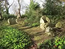
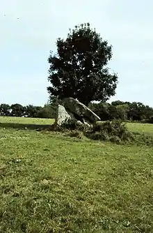
| Kilclooney More 1 | Dermot and Grania’s Bed | Ardara | Donegal | Es liegen zwei Portal Tombs im Abstand von nur ca. 9 m beisammen | 54,817547° N, 8,432328° W G 722 968 DG073-004---- |
.jpg.webp) |
| Kilclooney More 2 | Ardara | Donegal | Das Portal Tomb liegt ca. 1 km westlich von Kilclooney More 1 | 54,81251° N, 8,4472° W G 713 961 DG073-006---- |
 | |
| Lagkaghatermon | Dermot and Grania’s Bed | Donegal | 54,8091° N, 8,35567° W G 773 957 DG074-002---- |
|||
| Lisnanees Upper | Dermot and Grania’s Bed | Letterkenny | Donegal | Auf NMS: unclassified | 54,98586° N, 7,69569° W C 196 155 DG053-010---- |
|
| Malin More Málainn Mhóir |
Dermot and Grania’s Bed | Glencolumbkille | Donegal | Eine Reihe von sechs Portal Tombsn | 54,689709° N, 8,775845° W G 502 826 DG089-008----bis DG089-008005- |
 |
| Malin More Málainn Mhóir |
Glencolumbkille | Donegal | 54,695762° N, 8,764793° W G 507 833 DG089-004---- |
|||
| Malin More Málainn Mhóir |
Dermot and Grania’s Bed | Glencolumbkille | Donegal | 54,69362° N, 8,75004° W G 517 831 DG089-005---- |
||
| Malin More Málainn Mhóir |
Cloghnacarra | Glencolumbkille | Donegal | 54,69304° N, 8,74872° W G 518 830 DG089-006001- |
||
| Muntermellan | Dermot and Grania’s Bed | Horn Head | Donegal | 55,19598° N, 7,97219° W C 018 388 DG015-013---- |
||
| Roshin South An Roisín Theas |
Dungloe | Donegal | 54,934036° N, 8,428803° W B 725 097 DG048-009---- |
 | ||
| Sand Island | Donegal | 54,76675° N, 8,49572° W G 681 912 DG073-036---- |
||||
| Strabrinna Upper Srath Bruithne Uachta |
Kilcar | Donegal | Nur auf NMS beschrieben. | 54,64747° N, 8,55552° W G 641 778 DG091-005---- |
||
| Straleel North Srath Laoill Thuaidh |
Dermot and Grania’s Bed | Carrick | Donegal | 54,69095° N, 8,63872° W G 588 827 DG090-001---- |
 | |
| Templemoyle | Culdaff | Donegal | 55,292969° N, 7,210328° W C 502 498 DG004-035---- |
 | ||
| Toome Tuaim |
Dermot and Grania’s Bed | Gweebarra Bridge | Donegal | 54,85967° N, 8,32476° W B 792 014 DG065-005---- |
||
| Annadorn | Downpatrick | Down | Nur auf Megalithomania beschrieben; bei NISMR:Passage Tomb | 54,341981° N, 5,803644° W J 429 459 DOW030:007 |
||
| Ballygraffan | Comber | Down | Nur auf Megalithomania beschrieben; auf NISMR: Megalithic Structure | 54,531683° N, 5,725144° W J 473 672 DOW010:033 |
||
| Castle Ward[6][7] | Down | Kann auch ein Menhir sein | 54,373885° N, 5,585071° W J 569 499 DOW031:017 |
|||
| Goward | Pat Kearney’s Big Stone | Hilltown | Down | 54,213111° N, 6,094417° W J 244 310 DOW048:011 |
 | |
| Greengraves | The Kempe Stones | Dundonald | Down | 54,589988° N, 5,765357° W J 446 736 DOW005:028 |
 | |
| Kilfeaghan | Down | 54,07275° N, 6,118472° W J 232 154 DOW055:018 |
 | |||
| Kilkeel | The Crawtree Stone | Down | 54,066274° N, 6,00308° W J 307 148 DOW056:025 |
 | ||
| Legananny | Down | 54,323056° N, 6,020139° W J 288 434 DOW035:037 |
 | |||
| Loughmoney | Downpatrick | Down | Nur auf Megalithomania und NISMR beschrieben. | 54,34262° N, 5,63406° W J 539 464 DOW031:002 |
 | |
| Slievenagriddle | Downpatrick | Down | Nur auf NISMR als möglich beschrieben. | 54,333952° N, 5,649353° W J 529 453 DOW038-015 |
||
| Wateresk | Slipperyford | Newcastle | Down | 54,239528° N, 5,863139° W J 394 344 DOW043:061 |
.JPG.webp) | |
| Ballybrack | Dublin | 53,245128° N, 6,122301° W O 254 232 DU026-030---- |
 | |||
| Brenanstown | Druid’s Altar – Glendruid | Cabinteely | Dublin | 53,25384° N, 6,157783° W O 229 242 DU026-007---- |
 | |
| Cunard | Dublin Mountains | Dublin | Nur auf Megalithomania und NMS beschrieben. | 53,146° N, 6,330194° W O 117 195 DU025-051---- |
 | |
| Howth Demesne | Aideen’s Grave | Howth | Dublin | 53,379226° N, 6,082144° W O 276 383 DU015-032---- |
 | |
| Killiney | The Druid’s Judgement Chair | Dublin | Während des Viktorianischen Zeitalters „umgebaut“. Nur auf Megalithomania beschrieben; bei NMS: megalithische Struktur | 53,25813° N, 6,1202° W O 255 247 DU026-010---- |
 | |
| Kilmashogue | Larch Hill Dolmen | Dublin | 53,25224° N, 6,28204° W O 147 238 DU025-006---- |
|||
| Kiltiernan Domain | Dublin | 53,238639° N, 6,20715° W O 198 224 DU026-019---- |
||||
| Taylorsgrange | Brehon’s Chair | Dublin | Teils auch als Passage Tomb beschrieben | 53,267832° N, 6,264777° W O 158 255 DU022-033---- |
 | |
| Woodtown | Mount Venus Dolmen | Dublin | 53,261333° N, 6,310472° W O 128 247 DU025-002---- |
 | ||
| Glengesh | Fermanagh | 54,436397° N, 7,399008° W H 391 544 FER194:012 |
||||
| Kilrooskagh | Fermanagh | 54,308498° N, 7,906462° W H 061 399 FER227:009 |
||||
| Ballynacloghy | Clarinbridge | Galway | 53,225506° N, 8,976644° W M 348 199 GA094-012---- |
 | ||
| Ballynew | Galway | 53,5575° N, 10,07475° W L 626 584 GA022-008---- |
||||
| Carrownakib | Headford | Galway | Nur auf Megalithomania beschrieben. NMI: unclassified. | 53,453719° N, 9,181811° W M 215 455 GA055-069---- |
||
| Cloonlooaun | Galway | Nur auf NMS beschrieben. | 53,592626° N, 10,010862° W L 669 622 GA009-010---- |
 | ||
| Crannagh | Dermot and Grania’s Bed | Gort | Galway | 53,100978° N, 8,858205° W M 426 059 GA122-072---- |
 | |
| Knockavally | Clifden | Galway | 53,507983° N, 10,10582° W L 603 529 GA022-047---- |
|||
| Leagaun/Leagun | Galway | Auf Megalithomania und NMS beschrieben. | 53,524557° N, 10,123087° W L 592 548 GA022-051---- |
|||
| Marblehill | Galway | 53,086793° N, 8,467077° W M 688 041 GA022-051---- |
 | |||
| Menlough | Galway City | Galway | 53,31° N, 9,07° W M 287 294 GA082-067---- |
|||
| Killacloghan (E) | Milltown | Kerry | Nur auf NMS beschrieben. | 52,15479° N, 9,68621° W O 847 016 KE047-059---- |
||
| Killacloghan (W) | Milltown | Kerry | Nur auf NMS beschrieben. | 52,15112° N, 9,69964° W O 837 012 KE047-052---- |
||
| Ballyhenebery | Piltown | Kilkenny | 52,368444° N, 7,347222° W S 445 243 KK038-009---- |
|||
| Glencloghlea | New Ross | Kilkenny | 52,39649° N, 6,9882° W S 690 277 KK037-023---- |
 | ||
| Kilmogue | Harristown Dolmen, Leac an Scail |
Mullinavat | Kilkenny | 52,403257° N, 7,26162° W S 503 282 KK035-044---- |
 | |
| Killonerry | Carrick-on-Suir | Kilkenny | 52,368642° N, 7,389435° W S 416 242 KK038-005---- |
 | ||
| Newmarket | Kilkenny | 52,466748° N, 7,258526° W S 505 352 KK031-031---- |
 | |||
| Owning | Kilkenny | 52,390631° N, 7,340561° W S 449 268 KK035-053---- |
 | |||
| Raheen | Kilkenny | Nur auf NMS beschrieben. | 52,378775° N, 7,296071° W S 479 254 KK039-044---- |
|||
| Tubbrid | Kilkenny | Nur auf NMS beschrieben. | 52,34342° N, 7,23908° W S 518 216 KK039-064---- |
 | ||
| Aghanlish | Kinlough | Leitrim | Megalithomania; Reste eines Portal Tombs. NMS: zwei Standing Stones. | 54,4186° N, 8,29917° W G 807 523 LE003-002---- |
||
| Aghavas | Carrigallen | Leitrim | Nur auf Megalithomania und NMS beschrieben. | 53,9582° N, 7,71938° W H 184 010 LE033-016---- |
||
| Annaghmore | Mohill | Leitrim | 53,882361° N, 7,785336° W N 141 926 |
|||
| Cloonfinnan | Mohill | Leitrim | 53,90908° N, 7,91776° W N 055 955 LE032-086---- |
|||
| Creevy | Ballinamore | Leitrim | 54,04404° N, 7,83677° W H 107 105 LE025-063---- |
 | ||
| Drumany | Giant’s Grave | Leitrim | 54,0389° N, 7,88923° W H 073 098 LE024-027---- |
|||
| Fenagh Beg | Leitrim | 54,022842° N, 7,8352° W H 108 081 LE025-092---- |
 | |||
| Lear | Leitrim | Nur auf NMS beschrieben. | 53,8971° N, 7,8097° W N 125 942 LE036-012---- |
|||
| Loughscur | Leitrim | Nur auf Megalithomania und NMS beschrieben. | 54,019346° N, 7,96519° W H 023 078 LE024-044---- |
 | ||
| Sunnagh More | Leitrim | 53,93547° N, 7,77007° W N 152 984 LE033-025---- |
||||
| Sunnagh More | Leitrim | Liegt 600 m südlich des 1. Sunnagh More Portal Tombs | 53,93011° N, 7,76986° W N 152 978 LE033-027---- |
|||
| Tawnamachugh | Leitrim | 54,35071° N, 8,31123° W G 798 448 LE006-026---- |
||||
| Wardhouse (LE001-020) | Giant’s Grave | Leitrim | 200 m von der Küste entfernt. | 54,46875° N, 8,34744° W G 773-577 LE001-020---- |
 | |
| Wardhouse (LE001-022) | Leitrim | Ca. 100 m NE von Nr. 1. Nur auf Megalithomania und NMS beschrieben. | 54,46961° N, 8,34641° W G 775-580 LE001-022---- |
 | ||
| Aughnacliff | Longford | 53,847194° N, 7,600389° W N 263 887 34 LF006-017---- |
 | |||
| Birrinagh | Arvagh | Longford | Nur auf Megalithomania und NMS beschrieben. | 53,907349° N, 7,609297° W N 257 954 LE033-015---- |
.jpg.webp) | |
| Cleenrah | Grania’s Bed | Longford | 53,856842° N, 7,59617° W N 267 897 LF006-004---- |
 | ||
| Aghnaskeagh | Dundalk | Louth | 54,06108° N, 6,35795° W J 076 137 LH004-032---- |
 | ||
| Lurgankeel | Dundalk | Louth | 54,04378° N, 6,43829° W J 023 116 LH004-056---- |
 | ||
| Monascreebe | Louth | 54,06135° N, 6,40909° W J 042 136 LH004-016---- |
 | |||
| Proleek | Giant’s Grave, Ballymascanlan | Dundalk | Louth | 54,037244° N, 6,347861° W J 083 110 LH004-074---- |
 | |
| Ballyknock (NW) | Ballycastle | Mayo | 54,289414° N, 9,408487° W G 083 388 MA006-024---- |
|||
| Ballyknock (SO) | Ballycastle | Mayo | 54,287154° N, 9,404388° W G 086 385 MA007-043---- |
|||
| Claggan An Cloigeann |
Mayo | 53,971472° N, 9,838338° W F 794 039 MA056-005---- |
||||
| Doogort West | Giant’s Grave | Achill Island | Mayo | 53,997103° N, 10,056787° W F 652 073 MA042-021021- |
 | |
| Enagh Beg | Crossmolina | Mayo | Nur auf Megalithomania und NMS beschrieben. | 54,111078° N, 9,367698° W G 106 189 MA029-035---- |
 | |
| Gortbrack North An Gort Breac Thuaidh |
Mayo | 54,250657° N, 9,844457° W F 798 351 MA011-008---- |
 | |||
| Knocknalower Cnoc na Lobhar |
Mayo | 54,245272° N, 9,820555° W F 814 344 MA011-009---- |
||||
| Prebaun | Foxford | Mayo | Nur auf Megalithomania und NMS beschrieben. | 54,000083° N, 9,020836° W G 331 061 MA049-044001 |
 | |
| Slievemore[8] | Achill Island | Mayo | Auf Megalitomania beschrieben; NMS: unclassified | 53,99889° N, 10,134124° W F 601 076 MA042-012---- |
||
| Ervey | Kingscourt | Meath | 53,881428° N, 6,828636° W N 770 931 ME002-025---- |
 | ||
| Rathkenny | Meath | Nur auf Megalithomania und NMS beschrieben. | 53,760889° N, 6,653111° W N 888 799 ME012-035---- |
 | ||
| Corleanamaddy | Ballybay | Monaghan | Nur auf Megalithomania und NMS beschrieben. | 54,143789° N, 6,825438° W H 769 218 MO019-027---- |
||
| Garran | Giant’s Grave | Newbliss | Monaghan | 54,177798° N, 7,08672° W H 597 258 MO012-081---- |
 | |
| Lennan | Ballybay | Monaghan | 54,152933° N, 6,860222° W H 745 233 MO019-016---- |
|||
| Drumanone | Boyle | Roscommon | 53,970145° N, 8,354389° W G 768 024 RO005-015---- |
 | ||
| Knockanyconor | Nellie’s Rock | Lecarrow | Roscommon | Nur auf Megalithomania und NMS beschrieben. | 53,544561° N, 8,054021° W M 965 549 RO045-053001- |
 |
| Mihanboy | Athlone | Roscommon | 53,411944° N, 8,019722° W M 986 402 RO051-043001- |
 | ||
| Ardabrone | Sligo | 54,256311° N, 8,689989° W G 551 344 SL013-052---- |
 | |||
| Ballindoon | Lough Arrow | Sligo | Nur auf Megalithomania beschrieben, NMS: unclassified. | 54,085317° N, 8,320814° W G 791 152 SL034-206---- |
 | |
| Camcuill | Sligo | 54,226658° N, 8,925337° W G 397 313 SL017-021---- |
||||
| Carrickglass | Labby Rock Giant’s Grave |
Sligo | 54,090544° N, 8,312727° W G 796 157 SL034-152---- |
 | ||
| Cloghcor | Druid’s Altar | Sligo | 54,341311° N, 8,617345° W G 599 438 SL007-026---- |
|||
| Crowagh or Dunneill Mountain | Giant’s Grave | Sligo | 54,211206° N, 8,887213° W G 422 295 |
 SL018-075---- SL018-075---- | ||
| Gorteen | Sligo | 54,408° N, 8,4034° W G 738 510 SL006-014---- |
||||
| Knockanbaun | Sligo | 54,222197° N, 8,917021° W G 402 308 SL017-040---- |
||||
| Knockatober | Giant’s Grave | Sligo | 54,19228° N, 8,412998° W G 731 271 SL021-058---- |
 | ||
| Knockatotaun | Giant’s Grave Druid’s Altar |
Tubbercurry | Sligo | Nur auf Megalithomania, bei NMS als „megalithische Struktur“ beschrieben. | 54,128167° N, 8,662083° W G 568 201 SL025-108---- |
|
| Moytirra West | Sligo | Von Seán Ó Nualláin als zerstört beschrieben, laut Megalithomania sind wesentliche Teile erhalten. | 54,079297° N, 8,287276° W G 813 143 SL035-075---- |
|||
| Springfield | Giant’s Grave | Castlebaldwin | Sligo | 54,103012° N, 8,399055° W G 739 172 SL034-088---- |
 | |
| Tawnatruffaun | The Giant’s Griddle | Sligo | 54,19823° N, 8,920873° W G 399 281 SL017-051---- |
 | ||
| Ardcroney | Tipperary | 52,938167° N, 8,140556° W R 905 875 TN015-022---- |
||||
| Creggane | Nenagh | Tipperary | Nur auf Megalithomania und NMS beschrieben. | 52,872903° N, 8,28138° W R 810 803 TN020-009---- |
||
| Lissava | Cahir | Tipperary | Nur auf NMS beschrieben. | 52,37493° N, 7,963707° W S 024 248 TS075-045---- |
 | |
| Altcloghfin | Tyrone | 54,507241° N, 7,129621° W H 564 624 TYR 052:023 |
 | |||
| Altdrumman | The Cloghogle | Carrickmore | Tyrone | 54,636014° N, 7,105986° W H 578 768 TYR 027:012 |
 | |
| Athenree | Omagh | Tyrone | 54,586165° N, 7,02741° W H 628 714 TYR 036:002 |
 | ||
| Ballyrenan | Cloghastucan | Newtownstewart | Tyrone | Östlich der Doppelanlage liegt ein zweites Portal Tomb | 54,695242° N, 7,421764° W H 373 832 TYR 017:035 |
_-_geograph.org.uk_-_1176691.jpg.webp) |
| Ballywholan | Carnfadrig Long Cairn |
Tyrone | 54,386589° N, 7,145738° W H 555 490 TYR 065:003 |
 | ||
| Bullock Park | Tyrone | Nur auf NISMR beschrieben. | 54,657656° N, 7,570315° W H 278 789 TYR024:029 |
 | ||
| Carncorran Glebe | Giant’s Grave | Castlederg | Tyrone | 54,688742° N, 7,554191° W H 288 824 TYR 024:008 |
 | |
| Cashel | Tyrone | Nur auf NISMR beschrieben. | 54,674126° N, 7,10256° W H 579 810 TYR027:063 |
|||
| Churchtown | Druid’s Altar | Castlederg | Tyrone | 54,715808° N, 7,587155° W H 266 854 TYR 016:018 |
 | |
| Cloghfin | Omagh | Tyrone | 54,595219° N, 7,198448° W H 519 722 035:007 |
 | ||
| Creggandevesky | Tyrone | 54,621313° N, 7,010299° W H 639 752 TYR 037:016 |
||||
| Crosh | Newtownstewart | Tyrone | 54,737529° N, 7,352668° W H 418 879 TYR 017:008 |
_-_geograph.org.uk_-_2756873.jpg.webp) | ||
| Dullaghan | Dromore | Tyrone | 54,543365° N, 7,518688° W H 312 662 TYR 041:003 |
 | ||
| Glenknock or Cloghogle | Newtownstewart | Tyrone | 54,7378° N, 7,361459° W H 411 879 TYR 017:009 |
 | ||
| Glenroan | Dermot and Grania’s Bed | Tyrone | 54,76736° N, 7,148914° W H 548 914 TYR 012:005 |
 | ||
| Keerin | Tyrone | 54,722861° N, 7,004535° W H 643 865 TYR 020:007 |
||||
| Killynaght | Rocking Stone | Artigarvan | Tyrone | 54,856467° N, 7,392092° W C 391 011 TYR 005:002 |
 | |
| Leitrim | Druid’s Altar | Castlederg | Tyrone | 54,667525° N, 7,651247° W H 225 799 TYR 023:007 |
 | |
| Letterbrat | Plumbridge | Tyrone | 54,769798° N, 7,268247° W H 471 915 TYR 011:013 |
 | ||
| Murnells | Dermot and Grania’s Bed | Tyrone | 54,624833° N, 6,947° W H 680 757 TYR 037:010 |
|||
| Radergan | Grania’s Grave | Tyrone | Nur auf Megalithomania beschrieben | 54,524487° N, 7,144047° W H 555 643 TYR 044:008 |
 | |
| Sandville Lisdivin Lower |
Tyrone | Nur auf Megalithomania beschrieben; NISM: possible portal tomb |
54,889744° N, 7,39593° W C 388 049 TYR002:012 |
 | ||
| Scraghy | Tyrone | 54,612603° N, 7,657788° W H 222 738 TYR 032:004 |
 | |||
| Ballindud | Waterford | Waterford | 52,227893° N, 7,118765° W S 602 087 WA017-016---- |
 | ||
| Ballynageeragh | Tramore | Waterford | 52,177726° N, 7,276922° W S 495 030 WA025-007---- |
 | ||
| Ballyquin | Mothel Dolmen | Waterford | 52,312491° N, 7,396982° W S 412 180 WA003-049---- |
 | ||
| Dunhill | Waterford | 52,169242° N, 7,262928° W S 505 021 WA025-029---- |
 | |||
| Gaulstown | Waterford | 52,20575° N, 7,210778° W S 540 063 WA017-027---- |
 | |||
| Gurteen Lower | Clonmel | Waterford | 52,358501° N, 7,614317° W S 263 230 WA002-005---- |
|||
| Knockeen | Tramore | Waterford | 52,207495° N, 7,15916° W S 575 065 WA017-034---- |
 | ||
| Savagetown | Waterford | 52,172425° N, 7,307086° W S 474 025 WA025-022---- |
 | |||
| Sheskin | Waterford | 52,331015° N, 7,449803° W S 376 200 WA003-023---- |
||||
| Whitestown East | Waterford | 52,274935° N, 7,378593° W S 424 139 WA007-024---- |
||||
| Ballybrittas | Bree Hill | Wexford | 52,428593° N, 6,636397° W S 928 316 WX031-010---- |
.jpg.webp) | ||
| Newbawn | Wexford | 52,339574° N, 6,783359° W S 830 215 WX035-052---- |
||||
| Brittas | Wicklow | 52,901182° N, 6,072025° W T 298 851 WI036-008---- |
 | |||
| Broomfields | Donard | Wicklow | 53,02807° N, 6,6255° W S 922 983 WI015-061---- |
 | ||
| Djouce Mountain | Coffin Stone | Roundwood | Wicklow | Zweifelhaft, nur auf Megalithomania beschrieben | 53,132472° N, 6,249829° W O 172 105 ??? |
|
| Glaskenny/Onagh | Glaskenny Cromlech | Enniskerry | Wicklow | 53,174776° N, 6,211° W O 197 153 WI007-033---- |
 | |
Vollständig zerstörte Portal Tombs
| Name (Townland) | Bekannt als | Ort | County | Bemerkung |
|---|---|---|---|---|
| Gortfad | Castlefinn | Donegal | Nur auf NMS beschrieben. SMR: DG079-008---- Zwischen 1984 und 1993 zerstört | |
| Ballynahattan | Kilkeel | Down | Vermutlich während des Zweiten Weltkriegs zerstört | |
| Ballylowra | Knocktopher | Kilkenny | ||
| Melkagh | Drumlish | Longford | SMR: LF005-007---- 1982–83 nahezu völlig zerstört; 1984–86 Ausgrabungen der Reste.[9] | |
Anzahl Portal Tombs pro County
Liegen mehrere Portal Tombs eng zusammen (in obiger Tabelle in einer Zeile aufgeführt), so werden sie nur einmal gezählt.
| County | Anzahl | County | Anzahl | County | Anzahl | County | Anzahl |
|---|---|---|---|---|---|---|---|
| Armagh | 5 | Donegal | 27 | Longford | 3 | Sligo | 13 |
| Antrim | 5 | Down | 11 | Louth | 4 | Tyrone | 23 |
| Cork | 3 | Derry/L'derry | 6 | Leitrim | 14 | Tipperary | 3 |
| Clare | 4 | Fermanagh | 2 | Meath | 2 | Waterford | 14 |
| Cavan | 12 | Galway | 9 | Monaghan | 3 | Wexford | 2 |
| Carlow | 7 | Kilkenny | 8 | Mayo | 9 | Wicklow | 4 |
| Dublin | 9 | Kerry | 2 | Roscommon | 3 | ||
Literatur
- William Copeland Borlase: The Dolmens of Ireland, their Distribution, structural Characteristics, and Affinities in other Countries; together with the Folk-lore attaching to them and Traditions of the Irish People. 3 Bände, Chapman & Hall, London 1897 (Online).
- Eammon Cody: Survey of the Megalithic tombs of Ireland. 6. County Donegal. Stationery Office, Dublin 2002, ISBN 0-7557-1248-X (PDF (Teil 1); 20,1 MB, PDF (Teil 2); 20,3 MB, PDF (Teil 3); 23,4 MB, PDF (Teil 4); 17,9 MB, PDF (Teil 5); 19,8 MB, PDF (Teil 6); 23 MB, PDF (Teil 7); 20,4 MB, PDF (Teil 8); 16,3 MB, PDF (Teil 9); 13 MB).
- Carleton Jones: Temples of Stone: Exploring the megalithic Tombs of Ireland. Collins, Cork 2007, ISBN 978-1-905172-05-4.
- Tatjana Kytmannow: Portal Tombs in the landscape. The chronology, morphology and landscape setting of the portal tombs of Ireland, Wales and Cornwall (= British Archaeological Reports. British Series. Band 455). Archaeopress, Oxford 2008, ISBN 978-1-4073-0251-5.
- Seán Ó Nualláin: Survey of the Megalithic tombs of Ireland. 5. Countiy Sligo. Stationery Office, Dublin 1989, ISBN 0-7076-0080-4 (PDF (Textband); 16,2 MB, PDF (Tafelband); 9,4 MB).
- Philip I. Powell: Dolmens of South-East Ireland. The Portal Tombs of Counties Carlow, Dublin, Kilkenny, Waterford, Wexford & Wicklow megalithicmonumentsofireland.com, Dublin 2011, ISBN 1-4564-1666-9.
- Ruaidhrí de Valera, Seán Ó Nualláin: Survey of the Megalithic tombs of Ireland. 1. County Clare. Stationery Office, Dublin 1961 (PDF (Textband); 13 MB).
- Ruaidhrí de Valera, Seán Ó Nualláin: Survey of the Megalithic tombs of Ireland. 2. County Mayo. Stationery Office, Dublin 1964 (PDF (Textband); 15,9 MB, PDF (Tafelband); 7,9 MB).
- Ruaidhrí de Valera, Seán Ó Nualláin: Survey of the Megalithic tombs of Ireland. 3. Counties Galway, Roscommon, Leitrim, Longford, Westmeath, Laoighis, Offaly, Kildare, Cavan. Stationery Office, Dublin 1972 (PDF (Textband); 17,9 MB, PDF (Tafelband); 4,8 MB).
- Ruaidhrí de Valera, Seán Ó Nualláin: Survey of the Megalithic tombs of Ireland. 4. Counties Cork, Kerry, Limerick, Tipperary. Stationery Office, Dublin 1982 (PDF (Textband); 14,9 MB, PDF (Tafelband); 8,1 MB).
- Elizabeth Shee Twohig: Irish Megalithic Tombs. Princes Risborough, Shire 1990. ISBN 0-7478-0094-4.
- Henry Welsh, June Welsh: The Prehistoric Burial Sites of Northern Ireland. Archaeopress, Oxford 2014, ISBN 978-1-78491-006-8.
Einzelnachweise
- Seán Ó Nualláin: Irish Portal Tombs: Topography, Siting and Distribution. Journal of the Royal Society of Antiquaries of Ireland 113, 1983, S. 75–105
- Historic Environment Viewer, auf webgis.archaeology.ie
- Northern Ireland Sites & Monument Record NISMR, auf apps.communities-ni.gov.uk
- Portal Tombs, auf megalithomania.com
- Peter Harbinson: Guide to National and Historic Monuments of Ireland, Gill and Macmillan 1992
- Archaeology Ireland. 23/4, 2009, S. 12.
- "Archaeology Ireland Vol.4 Nr.3 Herbst 1990, Seite 7
- G. Cooney, Brian MacCurtain, Valerie Keeley: Excavation of the Portal Tomb Site at Melkagh, Co. Longford. In: Proceedings of the Royal Irish Academy: Archaeology, Culture, History, Literature. Bd. 97C, No. 41, 1997, S. 195–244