Kreis Szentlőrinc
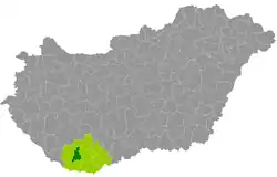
Der Kreis Szentlőrinc (ungarisch Szentlőrinci járás) ist Nachfolger des Kleingebiets Szentlőrinc (Szentlőrinci kistérség), das im Rahmen der ungarischen Verwaltungsreform Ende 2012 aufgelöst und in den gleichnamigen Nachfolgerkreis überführt wurde. Die 20 Gemeinden wurden noch um die Gemeinde Szentdénes aus dem Kleingebiet Szigetvár verstärkt. Der kleine Kreis liegt in der Mitte des Komitats, die Bevölkerungsdichte liegt unter der des Komitats.
| Kreis Szentlőrinci járás Szentlőrinc | |
|---|---|
 Lage des Kreises in Ungarn | |
| Basisdaten | |
| Staat | Ungarn |
| Komitat | Baranya |
| Sitz | Szentlőrinc |
| Fläche | 282,4 km² |
| Einwohner | 14.418 (1. Januar 2016) |
| Dichte | 51 Einwohner pro km² |
Gemeindeübersicht
| Gemeinde | Status | Herkunft Kleingebiet |
Einwohnerzahl | Fläche | Bevölkerungs- dichte (Ew./km²) | ||
|---|---|---|---|---|---|---|---|
| 01.10.2011 | 01.01.2013 | 01.01.2016 | |||||
| Bicsérd | Gemeinde | Szentlőrinc | 1.031 | 1.005 | 1.001 | 19,75 | 50,7 |
| Boda | Gemeinde | Szentlőrinc | 422 | 416 | 415 | 15,42 | 26,9 |
| Bükkösd | Gemeinde | Szentlőrinc | 1.116 | 1.104 | 1.092 | 30,15 | 36,2 |
| Cserdi | Gemeinde | Szentlőrinc | 386 | 392 | 386 | 6,46 | 59,8 |
| Csonkamindszent | Gemeinde | Szentlőrinc | 165 | 159 | 151 | 5,53 | 27,3 |
| Dinnyeberki | Gemeinde | Szentlőrinc | 93 | 81 | 84 | 8,56 | 9,8 |
| Gerde | Gemeinde | Szentlőrinc | 541 | 540 | 509 | 12,76 | 39,9 |
| Gyöngyfa | Gemeinde | Szentlőrinc | 136 | 140 | 140 | 8,78 | 15,9 |
| Helesfa | Gemeinde | Szentlőrinc | 522 | 516 | 477 | 9,87 | 48,3 |
| Hetvehely | Gemeinde | Szentlőrinc | 466 | 487 | 504 | 21,38 | 23,6 |
| Kacsóta | Gemeinde | Szentlőrinc | 273 | 272 | 262 | 9,51 | 27,5 |
| Királyegyháza | Gemeinde | Szentlőrinc | 957 | 956 | 881 | 22,89 | 38,5 |
| Okorvölgy | Gemeinde | Szentlőrinc | 80 | 85 | 71 | 3,11 | 22,8 |
| Pécsbagota | Gemeinde | Szentlőrinc | 90 | 94 | 100 | 6,07 | 16,5 |
| Sumony | Gemeinde | Szentlőrinc | 422 | 430 | 425 | 20,21 | 21,0 |
| Szabadszentkirály | Gemeinde | Szentlőrinc | 794 | 793 | 726 | 12,69 | 57,2 |
| Szentdénes | Gemeinde | Szigetvár | 302 | 288 | 285 | 12,15 | 23,5 |
| Szentkatalin | Gemeinde | Szentlőrinc | 93 | 91 | 85 | 13,31 | 6,4 |
| Szentlőrinc | Stadt | Szentlőrinc | 6.662 | 6.750 | 6.401 | 27,81 | 230,2 |
| Velény | Gemeinde | Szentlőrinc | 140 | 140 | 109 | 7,09 | 15,4 |
| Zók | Gemeinde | Szentlőrinc | 307 | 305 | 314 | 8,93 | 35,2 |
| Kreis Szentlőrinc | 14.998 | 15.044 | 14.418 | 282,43 | 51,0 | ||
Einzelnachweise
- KSH: 2011. Évi Népszámlálás. In: 3. Területi adatok. KSH, abgerufen am 24. Dezember 2016 (ungarisch, auch über: http://www.terezvaros.hu/testuleti/nepsz2011-3/pdf/nepsz2011_03_02.pdf).
- KSH: Regional data – Baranya county. KSH, abgerufen am 24. Dezember 2016 (englisch, 4. Data on Localities).
- KSH: Gazetteer of Hungary, 1st January, 2013. KSH, abgerufen am 8. März 2017 (ungarisch/englisch).
- KSH: Gazetteer of Hungary, 1st January, 2016. KSH, abgerufen am 8. März 2017 (ungarisch/englisch).
This article is issued from Wikipedia. The text is licensed under Creative Commons - Attribution - Sharealike. The authors of the article are listed here. Additional terms may apply for the media files, click on images to show image meta data.