Hodruša-Hámre
Hodruša-Hámre ist eine Gemeinde in der Mittelslowakei.
| Hodruša-Hámre | |||
|---|---|---|---|
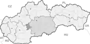
| Wappen | Karte | ||
 |
| ||
| Basisdaten | |||
| Staat: | Slowakei | ||
| Kraj: | Banskobystrický kraj | ||
| Okres: | Žarnovica | ||
| Region: | Pohronie | ||
| Fläche: | 46,13 km² | ||
| Einwohner: | 2.133 (31. Dez. 2020) | ||
| Bevölkerungsdichte: | 46 Einwohner je km² | ||
| Höhe: | 260 m n.m. | ||
| Postleitzahl: | 966 61 | ||
| Telefonvorwahl: | 045 | ||
| Geographische Lage: | 48° 28′ N, 18° 45′ O | ||
| Kfz-Kennzeichen: | ZC | ||
| Kód obce: | 516759 | ||
| Struktur | |||
| Gemeindeart: | Gemeinde | ||
| Gliederung Gemeindegebiet: | 3 Gemeindeteile | ||
| Verwaltung (Stand: November 2018) | |||
| Bürgermeister: | Jozef Uram | ||
| Adresse: | Obecný úrad Hodruša-Hámre 185 96661 Hodruša-Hámre | ||
| Webpräsenz: | www.hodrusa-hamre.sk | ||
| Statistikinformation auf statistics.sk | |||
Der Ort wurde 1971 aus den Gemeinden Banská Hodruša (wurde 1952 vor allem aus dem auf Deutsch als Hodritsch bekannten Teil von Banská Štiavnica gebildet) und Dolné Hámre (Unter-Hammer) gebildet. 1980 wurde dann noch die Gemeinde „Kopanice“ (Gerode) angeschlossen.
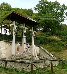
Kalvarienberg Ortsteil Banská Hodruša
Weblinks
Commons: Hodruša-Hámre – Sammlung von Bildern, Videos und Audiodateien
This article is issued from Wikipedia. The text is licensed under Creative Commons - Attribution - Sharealike. The authors of the article are listed here. Additional terms may apply for the media files, click on images to show image meta data.