Erdőbénye
Erdőbénye ist eine Gemeinde im Komitat Borsod-Abaúj-Zemplén.
| Erdőbénye | |||||
| |||||
| Basisdaten | |||||
|---|---|---|---|---|---|
| Staat: | Ungarn | ||||
| Region: | Nordungarn | ||||
| Komitat: | Borsod-Abaúj-Zemplén | ||||
| Kleingebiet bis 31.12.2012: | Tokaj | ||||
| Kreis seit 1.1.2013: | Tokaj | ||||
| Koordinaten: | 48° 16′ N, 21° 21′ O | ||||
| Höhe: | 165 m | ||||
| Fläche: | 48,80 km² | ||||
| Einwohner: | 1.037 (1. Jan. 2011) | ||||
| Bevölkerungsdichte: | 21 Einwohner je km² | ||||
| Telefonvorwahl: | (+36) 47 | ||||
| Postleitzahl: | 3932 | ||||
| KSH-kód: | 25326 | ||||
| Struktur und Verwaltung (Stand: 2007) | |||||
| Gemeindeart: | Gemeinde | ||||
| Bürgermeister: | Dezső Kántor | ||||
| Postanschrift: | Kossuth u 31. 3932 Erdőbénye | ||||
| Website: | |||||
| (Quelle: A Magyar Köztársaság helységnévkönyve 2011. január 1. bei Központi statisztikai hivatal) | |||||

Geografische Lage
Erdőbénye liegt im Norden Ungarns, 58 Kilometer vom Komitatssitz Miskolc entfernt. Nachbargemeinden sind Sima 7 km, Szegilong 7 km und Tolcsva 8 km. Die nächsten Städte Sárospatak, Encs, Tokaj und Abaújszántó liegen ca. 20 km von Erdőbénye entfernt.
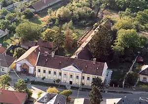
Luftaufnahme von Erdőbénye
This article is issued from Wikipedia. The text is licensed under Creative Commons - Attribution - Sharealike. The authors of the article are listed here. Additional terms may apply for the media files, click on images to show image meta data.