Communauté de communes du Pays du Saintois
Die Communauté de communes du Pays du Saintois ist ein französischer Gemeindeverband mit der Rechtsform einer Communauté de communes im Département Meurthe-et-Moselle in der Region Grand Est (bis 2015 Lothringen). Er wurde am 19. Dezember 2012 gegründet und umfasst 55 Gemeinden. Der Verwaltungssitz befindet sich im Ort Tantonville.[2]
| Communauté de communes du Pays du Saintois | |
| Region(en) | Grand Est |
| Département(s) | Meurthe-et-Moselle |
| Gründungsdatum | 19. Dezember 2012 |
| Rechtsform | Communauté de communes |
| Verwaltungssitz | Tantonville |
| Gemeinden | 55 |
| Präsident | Dominique Lemoine |
| SIREN-Nummer | 200 035 772 |
| Fläche | 350,59 km² |
| Einwohner | 14.314 (2019)[1] |
| Bevölkerungsdichte | 41 Einw./km² |
| Website | www.ccpaysdusaintois.fr |
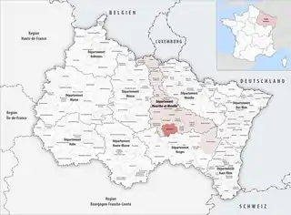 Lage des Gemeindeverbandes in der Region Grand Est | |
Mitgliedsgemeinden
| Gemeinde | Einwohner 1. Januar 2019 |
Fläche km² |
Dichte Einw./km² |
Code INSEE |
Postleitzahl |
|---|---|---|---|---|---|
| Affracourt | 109 | 5,63 | 19 | 54005 | 54740 |
| Autrey | 187 | 6,21 | 30 | 54032 | 54160 |
| Bainville-aux-Miroirs | 284 | 6,79 | 42 | 54042 | 54290 |
| Benney | 657 | 18,61 | 35 | 54062 | 54740 |
| Bouzanville | 64 | 5,85 | 11 | 54092 | 54930 |
| Bralleville | 173 | 4,48 | 39 | 54094 | 54740 |
| Ceintrey | 933 | 11,08 | 84 | 54109 | 54134 |
| Chaouilley | 115 | 5,12 | 22 | 54117 | 54330 |
| Clérey-sur-Brenon | 63 | 4,42 | 14 | 54132 | 54330 |
| Crantenoy | 158 | 5,23 | 30 | 54142 | 54740 |
| Diarville | 502 | 11,19 | 45 | 54156 | 54930 |
| Dommarie-Eulmont | 87 | 5,47 | 16 | 54164 | 54115 |
| Étreval | 60 | 2,39 | 25 | 54185 | 54330 |
| Forcelles-Saint-Gorgon | 138 | 5,32 | 26 | 54203 | 54330 |
| Forcelles-sous-Gugney | 93 | 5,41 | 17 | 54204 | 54930 |
| Fraisnes-en-Saintois | 100 | 6,48 | 15 | 54207 | 54930 |
| Gerbécourt-et-Haplemont | 230 | 5,35 | 43 | 54221 | 54740 |
| Germonville | 123 | 5,19 | 24 | 54224 | 54740 |
| Goviller | 421 | 12,25 | 34 | 54235 | 54330 |
| Gripport | 271 | 5,77 | 47 | 54238 | 54290 |
| Gugney | 75 | 2,92 | 26 | 54241 | 54930 |
| Hammeville | 177 | 5,54 | 32 | 54247 | 54330 |
| Haroué | 506 | 4,30 | 118 | 54252 | 54740 |
| Houdelmont | 284 | 3,86 | 74 | 54264 | 54330 |
| Houdreville | 407 | 10,39 | 39 | 54266 | 54330 |
| Housséville | 142 | 5,34 | 27 | 54268 | 54930 |
| Jevoncourt | 99 | 3,34 | 30 | 54278 | 54740 |
| Lalœuf | 291 | 10,99 | 26 | 54291 | 54115 |
| Laneuveville-devant-Bayon | 226 | 5,79 | 39 | 54299 | 54740 |
| Lebeuville | 176 | 6,24 | 28 | 54307 | 54740 |
| Lemainville | 379 | 4,79 | 79 | 54309 | 54740 |
| Leménil-Mitry | 3 | 3,48 | 1 | 54310 | 54740 |
| Mangonville | 218 | 3,86 | 56 | 54344 | 54290 |
| Neuviller-sur-Moselle | 248 | 6,95 | 36 | 54399 | 54290 |
| Ognéville | 96 | 4,15 | 23 | 54407 | 54330 |
| Omelmont | 188 | 4,68 | 40 | 54409 | 54330 |
| Ormes-et-Ville | 218 | 12,52 | 17 | 54411 | 54740 |
| Parey-Saint-Césaire | 240 | 5,57 | 43 | 54417 | 54330 |
| Praye | 252 | 8,74 | 29 | 54434 | 54116 |
| Quevilloncourt | 97 | 2,90 | 33 | 54442 | 54330 |
| Roville-devant-Bayon | 769 | 4,46 | 172 | 54465 | 54290 |
| Saint-Firmin | 280 | 6,70 | 42 | 54473 | 54930 |
| Saint-Remimont | 355 | 6,74 | 53 | 54486 | 54740 |
| Saxon-Sion | 106 | 6,25 | 17 | 54497 | 54330 |
| Tantonville | 646 | 8,14 | 79 | 54513 | 54116 |
| They-sous-Vaudemont | 17 | 1,66 | 10 | 54516 | 54930 |
| Thorey-Lyautey | 142 | 6,24 | 23 | 54522 | 54115 |
| Vaudémont | 62 | 5,78 | 11 | 54552 | 54330 |
| Vaudeville | 150 | 9,12 | 16 | 54553 | 54740 |
| Vaudigny | 77 | 4,00 | 19 | 54554 | 54740 |
| Vézelise | 1.392 | 5,36 | 260 | 54563 | 54330 |
| Vitrey | 195 | 11,69 | 17 | 54587 | 54330 |
| Voinémont | 330 | 4,14 | 80 | 54591 | 54134 |
| Vroncourt | 260 | 4,18 | 62 | 54592 | 54330 |
| Xirocourt | 443 | 11,54 | 38 | 54597 | 54740 |
| Communauté de communes du Pays du Saintois |
14.314 | 350,59 | 41 | – | – |
Quellen
- www.collectivites-locales.gouv.fr
- CC du Pays du Saintois (SIREN: 200 035 772) in der Base nationale sur l’intercommunalité (BANATIC) des französischen Innenministeriums (französisch)
(Stand: 1. Januar 2018)
Bassin de Pompey | Bassin de Pont-à-Mousson | Mad et Moselle* | Meurthe Mortagne Moselle | Moselle et Madon | Orne Lorraine Confluences | Pays de l’Audunois et du Bassin de Landres* | Pays de Colombey et du Sud Toulois* | Pays Haut Val d’Alzette* | Pays du Saintois | Pays du Sânon | Pays du Sel et du Vermois | Seille et Grand Couronné | Terre Lorraine du Longuyonnais | Terres Touloises | Territoire de Lunéville à Baccarat | Vezouze en Piémont
Communautés d’agglomération
Longwy |
Saint-Dié-des-Vosges*
Den mit * gekennzeichneten Gemeindeverbänden gehören auch Gemeinden an, die in anderen Départements liegen.