Biała (Trzcianka)
Biała (deutsch Behle) ist ein Dorf in der Woiwodschaft Großpolen in Polen und gehört als Schulzenamt zur Gemeinde Trzcianka.[2] Es liegt 5 km östlich von deren Hauptort Trzcianka, 17 km nördlich von Czarnków und 76 km nördlich von Posen.
| Biała | |||
|---|---|---|---|
| ? Hilfe zu Wappen |
| ||
| Basisdaten | |||
| Staat: | Polen | ||
| Woiwodschaft: | Großpolen | ||
| Powiat: | Czarnków-Trzcianka | ||
| Gmina: | Trzcianka | ||
| Geographische Lage: | 53° 3′ N, 16° 32′ O | ||
| Einwohner: | 1021 (31. März 2011[1]) | ||
| Postleitzahl: | 64-904 | ||
| Telefonvorwahl: | (+48) 67 | ||
| Kfz-Kennzeichen: | PCT | ||
| Wirtschaft und Verkehr | |||
| Eisenbahn: | Piła–Krzyż | ||
| Verwaltung | |||
| Webpräsenz: | www.biala-trzcianka.republika.pl | ||

Biała hat etwa 1.000 Einwohner.
In den 1920er-Jahren war Ludwig Polzin Kaplan in Biała (damals offiziell Behle).
Weblinks
Commons: Biała (Trzcianka) – Sammlung von Bildern, Videos und Audiodateien
Einzelnachweise
- GUS 2011: Ludność w miejscowościach statystycznych według ekonomicznych grup wieku (polnisch), 31. März 2011, abgerufen am 6. Juli 2017
- Central Statistical Office (GUS) - TERYT (National Register of Territorial Land Apportionment Journal) (polnisch) 1. Juni 2008.
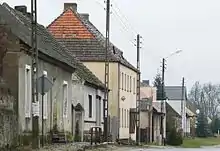
Straße in Biała
This article is issued from Wikipedia. The text is licensed under Creative Commons - Attribution - Sharealike. The authors of the article are listed here. Additional terms may apply for the media files, click on images to show image meta data.