Bacarra
Bacarra ist eine Stadtgemeinde in der philippinischen Provinz Ilocos Norte. Die Gemeinde grenzt im Westen an das Südchinesische Meer. In Bacarra befindet sich die Kirche San Andres Apostol, eine alte spanische Kirche. Direkt daneben steht ihr alter Glockenturm, der 1983 bei einem Erdbeben teilweise zerstört wurde. An der Küste befinden sich zwei große Sandstrände.
| Municipality of Bacarra | |||
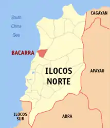
| Lage von Bacarra in der Provinz Ilocos Norte | |||
|---|---|---|---|
 | |||
| Basisdaten | |||
| Region: | Ilocos-Region | ||
| Provinz: | Ilocos Norte | ||
| Barangays: | 43 | ||
| Distrikt: | 1. Distrikt von Ilocos Norte | ||
| PSGC: | 012802000 | ||
| Einkommensklasse: | 3. Einkommensklasse | ||
| Haushalte: | 6289 Zensus 1. Mai 2000 | ||
| Einwohnerzahl: | 32.215 Zensus 1. August 2015 | ||
| Bevölkerungsdichte: | 487,6 Einwohner je km² | ||
| Fläche: | 66,07 km² | ||
| Koordinaten: | 18° 15′ N, 120° 37′ O | ||
| Postleitzahl: | 2916 | ||
| Bürgermeister: | Philip C. Velasco (Lakas-CMD) | ||
| Geographische Lage auf den Philippinen | |||
| |||

Baranggays
Bacarra ist in folgende 43 Baranggays aufgeteilt:
|
|
|
This article is issued from Wikipedia. The text is licensed under Creative Commons - Attribution - Sharealike. The authors of the article are listed here. Additional terms may apply for the media files, click on images to show image meta data.