42-es főút
42-es főút (ungarisch für ‚Hauptstraße 42‘) ist eine ungarische Hauptstraße und verläuft von Püspökladány nach Ártánd an der rumänischen Grenze.
| 42-es főút in Ungarn | |||||||||||||||||||||||||||||||
_Otszogletu_zold_tabla.svg.png.webp) | |||||||||||||||||||||||||||||||
| | |||||||||||||||||||||||||||||||
| Karte | |||||||||||||||||||||||||||||||
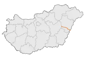 Verlauf der F42 | |||||||||||||||||||||||||||||||
| Basisdaten | |||||||||||||||||||||||||||||||
| Betreiber: | Magyar Közút Nonprofit Zrt. | ||||||||||||||||||||||||||||||
| Straßenbeginn: | Püspökladány (47° 19′ 17″ N, 21° 4′ 7″ O) | ||||||||||||||||||||||||||||||
| Straßenende: | Ártánd (47° 7′ 9″ N, 21° 47′ 22″ O) | ||||||||||||||||||||||||||||||
| Gesamtlänge: | 59 km | ||||||||||||||||||||||||||||||
|
Megyék (Komitate): |
|||||||||||||||||||||||||||||||
Straßenverlauf
| |||||||||||||||||||||||||||||||
Ihre Gesamtlänge beträgt 59 Kilometer.[1] Auf rumänischer Seite bildet die Drum național 1 ihre Fortsetzung.
Siehe auch
Weblinks
- Ungarische Öffentliche Straße Non-profit AG (Magyar Közút Nonprofit Zrt.) (ungarisch)
- Nationale Infrastruktur Entwickler geschlossene AG (ungarisch, teilweise englisch)
Einzelnachweise
- Magyarország, autóatlasz 1:200.000, Honvédelmi Minisztérium Térképészeti Kht., ISBN 978-963-257-087-7.
This article is issued from Wikipedia. The text is licensed under Creative Commons - Attribution - Sharealike. The authors of the article are listed here. Additional terms may apply for the media files, click on images to show image meta data.