Villaba
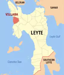
Villaba ist eine philippinische Stadtgemeinde in der Provinz Leyte auf der Insel Leyte. Sie hat 41.891 Einwohner (Zensus 1. August 2015), die in 35 Barangays leben. Die Gemeinde wird als teilweise urban beschrieben und gehört zur dritten Einkommensklasse der Gemeinden auf den Philippinen. Ihre Nachbargemeinden sind Tabango im Norden, Kananga im Osten und Matag-ob im Süden. Im Westen grenzt die Gemeinde an die Camotes-See der Insel Cebu gegenüber.
| Municipality of Villaba | |||
| Lage von Villaba in der Provinz Leyte (Provinz) | |||
|---|---|---|---|
 | |||
| Basisdaten | |||
| Region: | Eastern Visayas | ||
| Provinz: | Leyte (Provinz) | ||
| Barangays: | 35 | ||
| Distrikt: | 3. Distrikt von Leyte (Provinz) | ||
| PSGC: | 083751000 | ||
| Einkommensklasse: | 3. Einkommensklasse | ||
| Haushalte: | Zensus 1. Mai 2000 | ||
| Einwohnerzahl: | 41.891 Zensus 1. August 2015 | ||
| Bevölkerungsdichte: | 278,7 Einwohner je km² | ||
| Fläche: | 150,31 km² | ||
| Koordinaten: | 11° 13′ N, 124° 24′ O | ||
| Postleitzahl: | 6537 | ||
| Bürgermeister: | CLAUDIO MARTIN A. LARRAZABAL | ||
| Geographische Lage auf den Philippinen | |||
| |||

In der Gemeinde befindet sich ein Campus der Visayas State University.
Baranggays
|
|
|
Weblinks
This article is issued from Wikipedia. The text is licensed under Creative Commons - Attribution - Sharealike. The authors of the article are listed here. Additional terms may apply for the media files, click on images to show image meta data.