U.S. Highway 30
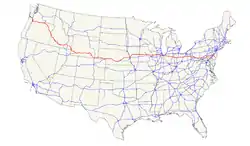
Der U.S. Highway 30 ist ein in Ost-West-Richtung verlaufender Highway mit einer Länge von 4946 km. Er entstand 1926. Im Westen beginnt er als US 101 in Astoria (Oregon) und endet im Osten als Interstate 95 in Atlantic City (New Jersey).
|
| |
|---|---|
| Karte | |
 | |
| Basisdaten | |
| Gesamtlänge: | 4946 km |
| Eröffnung: | 1926 |
| Bundesstaaten: | Oregon Idaho Wyoming Nebraska Iowa Illinois Indiana Ohio West Virginia Pennsylvania New Jersey |
| Anfangspunkt: | US 101 Astoria (Oregon) |
| Endpunkt: | Virginia Avenue Atlantic City (New Jersey) |

Verlauf und Streckenlängen
Weblinks
Einzelnachweise
- Oregon Department of Transportation: TransGIS und Equations and Milepoint Range Information (Memento vom 16. Juni 2004 im Internet Archive), abgerufen am 30. Januar 2006.
- Idaho Transportation Department: 4. Mai 2004 Milepost Log – State Highway System (Memento vom 14. Juli 2004 im Internet Archive)
- Wyoming Department of Transportation:, November 2004 Reference Marker Book (Memento vom 11. März 2007 im Internet Archive)
- Nebraska Roads: US 30
- Iowa Department of Transportation: 2004 Geographic Information Systems Statewide and County Data (Memento vom 17. August 2007 im Internet Archive)
- Illinois Department of Transportation: 2004 GIS Data (Memento vom 17. August 2004 im Internet Archive)
- Indiana Highway Ends – US 30 (Memento vom 8. Oktober 2012 im Internet Archive)
- Ohio Department of Transportation: 1. Januar 2005 Straight Line Diagrams (Memento vom 19. Februar 2003 im Internet Archive)
- Schätzung auf Grundlage des Kartenmaterials von MapQuest
- Lincoln Highway: US 30
- New Jersey Department of Transportation: 2005 Straight Line Diagrams – US 30 (PDF).
U.S. Highway 1 |
2 |
3 |
4 |
5 |
6 |
7 |
8 |
9 |
10 |
11 |
12 |
13 |
14 |
15 |
16 |
17 |
18 |
19 |
20 |
21 |
22 |
23 |
24 |
25 |
26 |
27 |
28 |
29 |
30 |
31 |
32 |
33 |
34 |
35 |
36 |
37 |
38 |
40 |
41 |
42 |
43 |
44 |
45 |
46 |
48 |
49 |
50 |
51 |
52 |
53 |
54 |
55 |
56 |
57 |
58 |
59 |
60 |
61 |
62 |
63 |
64 |
65 |
66 |
67 |
68 |
69 |
70 |
71 |
72 |
73 |
74 |
75 |
76 |
77 |
78 |
79 |
80 |
81 |
82 |
83 |
84 |
85 |
87 |
89 |
89A |
90 |
91 |
92 |
93 |
94 |
95 |
96 |
97 |
98 |
99 |
101 |
150 |
151 |
163 |
218 |
400 |
412 |
425
Diese Liste enthält die Hauptrouten des U.S.-Highway-Systems. Nebenrouten sind vom Artikel der jeweiligen Hauptroute (mit identischen Endziffern) erreichbar.
Siehe auch: Liste der United States Highways.