Savanne (Distrikt)
| Distrikt Savanne | |
|---|---|
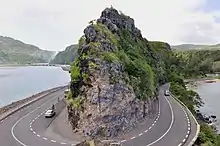
 Baie du Cap (2009) | |
| Basisdaten | |
| Bezirkshauptstadt: | Souillac |
| Fläche: | 244.8 km² |
| Einwohner: | 63585 (2015)[1] |
| Bevölkerungsdichte: | 280 Ew./km² |
| ISO 3166-2: | MU-SA |
| Zeitzone: | UTC+4 |
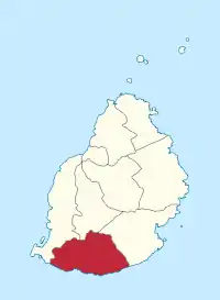
| Lage in Mauritius | |
 Karte | |
Savanne ist ein Bezirk auf dem Inselstaat Mauritius und liegt im Süden der Insel. Seine Bezirkshauptstadt ist Souillac.
Gemeinden
Mauritius ist zu Verwaltungszwecken in Gemeinden („Village Council Areas“) (VCA) eingeteilt. Die folgende Tabelle nennt die VCA die (zumindest teilweise) im Distrikt Black River liegen. Die Grenzen der Distrikte sind nicht deckungsgleich mit denen der Gemeinden. Gemeinden sind daher teilweise zwei oder drei Distrikten zugeordnet. Im Distrikt Black River liegen 16 Gemeinden (VCA).[2]
| Nr. | Ortsname | Abgrenzung |
|---|---|---|
| 1601 | Baie du Cap VCA | |
| 1602 | Bois Chéri VCA | |
| 1603 | Camp Diable VCA | |
| 1604 | Chemin Grenier VCA | |
| 1605 | Grand Bois VCA | |
| 1606 | Rivière des Anguilles VCA | |
| 1607 | Rivière du Poste VCA (West) | Ost im Distrikt Grand Port |
| 1608 | Souillac VCA | |
| 1609 | Surinam VCA | |
| 1610 | Bel Ombre VCA | |
| 1611 | Bénarès VCA | |
| 1612 | Britannia VCA | |
| 1613 | Chamouny VCA | |
| 1614 | L'Escalier VCA (West) | Ost im Distrikt Grand Port |
| 1615 | St. Aubin VCA | |
| 1616 | Chamarel VCA (Ost) | West im Distrikt Black River |
Einzelnachweise
- Ministry of Finance & Economic Development: ANNUAL DIGEST OF STATISTICS 2015 (PDF; 6,18 MB) Government of Mauritius. S. 19. August 2016. Abgerufen am 23. Dezember 2016.
- Statistics Mauritius: Housing and population census 2011, Volume II: Demographic and fertility characteristics, S. 137-141, statsmauritius.govmu.org (PDF)
This article is issued from Wikipedia. The text is licensed under Creative Commons - Attribution - Sharealike. The authors of the article are listed here. Additional terms may apply for the media files, click on images to show image meta data.