Santo Emilião
Santo Emilião ist eine Gemeinde im Norden Portugals.
| Santo Emilião | |||||
|---|---|---|---|---|---|
| |||||
| Basisdaten | |||||
| Region: | Norte | ||||
| Unterregion: | Ave | ||||
| Distrikt: | Braga | ||||
| Concelho: | Póvoa de Lanhoso | ||||
| Koordinaten: | 41° 32′ N, 8° 18′ W | ||||
| Einwohner: | 926 (Stand: 30. Juni 2011)[1] | ||||
| Fläche: | 2,14 km² (Stand: 1. Januar 2010)[2] | ||||
| Bevölkerungsdichte: | 433 Einwohner pro km² | ||||
| Postleitzahl: | 4830-649 | ||||
| Politik | |||||
| Adresse der Gemeindeverwaltung: | Junta de Freguesia de Santo Emilião Rua de S. Bento, nº40 4830-649 Santo Emilião | ||||
| Website: | www.freguesiasantoemiliao.pt | ||||

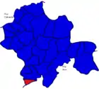
Santo Emilião gehört zum Kreis Póvoa de Lanhoso im Distrikt Braga, besitzt eine Fläche von 2,14 km² und hat 926 Einwohner (Stand 30. Juni 2011)[1].
Einzelnachweise
- www.ine.pt – Indikator Resident population by Place of residence and Sex; Decennial in der Datenbank des Instituto Nacional de Estatística
- Übersicht über Code-Zuordnungen von Freguesias auf epp.eurostat.ec.europa.eu
Weblinks
- Karte der Freguesia Santo Emilião beim Instituto Geográfico do Exército
- Information zu Santo Emilião. (pdf) mun-planhoso.pt, abgerufen am 30. Mai 2011 (portugiesisch).
Freguesias im Concelho Póvoa de Lanhoso
Águas Santas e Moure | Calvos e Frades | Campos e Louredo | Covelas | Esperança e Brunhais | Ferreiros | Fonte Arcada e Oliveira | Galegos | Garfe | Geraz do Minho | Lanhoso | Monsul | Póvoa de Lanhoso | Rendufinho | Santo Emilião | São João de Rei | Serzedelo | Sobradelo da Goma | Taíde | Travassos | Verim, Friande e Ajude | Vilela
This article is issued from Wikipedia. The text is licensed under Creative Commons - Attribution - Sharealike. The authors of the article are listed here. Additional terms may apply for the media files, click on images to show image meta data.