San Esteban (Ilocos Sur)
San Esteban ist eine Stadtgemeinde in der philippinischen Provinz Ilocos Sur und liegt am Südchinesischen Meer. Im Jahre 2015 lebten in dem nur 24 km² großen Gebiet 8349 Menschen, wodurch sich eine Bevölkerungsdichte von 348 Einwohnern pro km² ergibt. Das Gelände ist oft hügelig und zwischendurch flach. San Esteban besitzt an der Küste mehrere Strände und schöne Steinformationen.
| Municipality of San Esteban | |||
 | |||
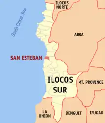
| Lage von San Esteban in der Provinz Ilocos Sur | |||
|---|---|---|---|
 | |||
| Basisdaten | |||
| Region: | Ilocos-Region | ||
| Provinz: | Ilocos Sur | ||
| Barangays: | 10 | ||
| Distrikt: | 2. Distrikt von Ilocos Sur | ||
| PSGC: | 012918000 | ||
| Einkommensklasse: | 5. Einkommensklasse | ||
| Haushalte: | 1482 Zensus 1. Mai 2000 | ||
| Einwohnerzahl: | 8.349 Zensus 1. August 2015 | ||
| Bevölkerungsdichte: | 347,9 Einwohner je km² | ||
| Fläche: | 24 km² | ||
| Koordinaten: | 17° 20′ N, 120° 26′ O | ||
| Postleitzahl: | 2706 | ||
| Bürgermeister: | Chester A. Elaydo | ||
| Website: | www.sanesteban.com.ph | ||
| Geographische Lage auf den Philippinen | |||
| |||

San Esteban ist in folgende zehn Baranggays aufgeteilt:
- Ansad
- Apatot
- Bateria
- Cabaroan
- Cappa-Cappa
- Poblacion
- San Nicolas
- San Pablo
- San Rafael
- Villa Quirino
Weblinks
This article is issued from Wikipedia. The text is licensed under Creative Commons - Attribution - Sharealike. The authors of the article are listed here. Additional terms may apply for the media files, click on images to show image meta data.