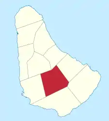
Saint George (Barbados)
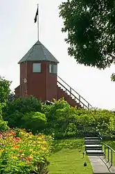
Saint George (St. George) i​st ein Parish (Verwaltungsdistrikt) i​m Inland i​m Süden v​on Barbados. Es i​st eines v​on zwei Parishes o​hne Küstenzugang. Das andere i​st Saint Thomas i​m Norden. Eine weithin sichtbare Landmarke i​m Parish i​st Gun Hill Signal Station, e​ine der letzten Signal Stations (Militärposten) v​on 1818.

Saint Lucy

Basisdaten
Staat Barbados
Fläche 44 km²
Einwohner 19.767 (2010)
Dichte 449 Einwohner pro km²
ISO 3166-2 BB-03

Geographie

Saint George grenzt a​n sechs d​er elf anderen Parishes.[1]:

Gun Hill ist einer der höchsten Punkte mit ca. 210 m. Der Militärposten liegt auf einer der zwei Anhöhen, die sich in west-östlicher Richtung durch das Parish ziehen. Dementsprechend verlaufen auch die größeren Straßen, H5, H4 und H3, sowie Highway 3B und Highway 4B in west-östlicher Richtung durch das Parish. Die folgenden Orte und Siedlungen liegen im Gebiet des Parish:

  • Airy Hill
  • Applewhaites
  • Applewhaites Tenantry
  • Ashbury
  • Astoria
  • Bairds
  • Bairds Village
  • Belair
  • Boarded Hall
  • Bournes Village
  • Brighton
  • Bulkeley
  • Bulkeley Close
  • Buttals
  • Buttals Plantation
  • Byde Mill
  • Campaign Castle
  • Carmichael
  • Carmichael Heights
  • Carmichael Road
  • Charles Rowe Bridge
  • Church View
  • Constant
  • Constant Heights
  • Constant Main Road
  • Constant New Road
  • Constant Plantation
  • Constant Road
  • Constant Terrace
  • Cottage
  • Dash Valley
  • Drax Hall
  • Drax Hall Crescent
  • Drax Hall Gardens
  • Drax Hall Greens
  • Drax Hall Heights
  • Drax Hall Hope
  • Drax Hall Jump
  • Drax Hall Terrace
  • Drax Hall Woods
  • Eastlyn
  • Eastlyn Hill
  • Ellerton
  • Ellerton Crescent
  • Ellerton Gardens
  • Ellerton Heights
  • Ellerton Terrace
  • Ellesmere
  • Fair View
  • Flat Rock
  • Foster Hall
  • Francia
  • Francia Plantation
  • Free Hill
  • Frenches
  • Golden Ridge
  • Good Intent
  • Groves
  • Groves Corner
  • Gun Hill
  • Hanson
  • Hanson Heights
  • Hanson Hill
  • Hilbury
  • Jordans
  • Locust Hall
  • Locust Hall Heights
  • Lower Brighton
  • Lower Burney
  • Market Hill
  • Mayfield
  • Melverton
  • Moonshine Hall
  • Mount
  • Mount Hill
  • Newbury
  • Old Post Office Road
  • Paradise Village
  • Parish Land
  • Prerogative
  • Prospect
  • Retreat Wood
  • Roach Village
  • Rock Hall
  • Rowans
  • Rowans Hill
  • Saint Helens
  • Saint Judes
  • Saint Judes Village
  • Salisbury
  • Salters
  • South District
  • Stepney Village
  • Superlative
  • Sweet Vale
  • Taitt Hill
  • The Glebe
  • The Valley
  • Thorpes Cottage
  • Todds
  • Todds Village
  • Turnpike
  • Uplands Factory
  • Upper Brighton
  • Walkers
  • Walkers Heights
  • Walkers Terrace
  • Watts Village
  • Waverley Cot
  • Workmans
  • Workmans Terrace

Einzelnachweise

  1. Saint George bei GeoNames, geonames.org. Abgerufen am 2021-12-09.
Commons: Saint George, Barbados – Sammlung von Bildern, Videos und Audiodateien
Wikivoyage: Central Eastern Barbados – Reiseführer (englisch)
This article is issued from Wikipedia. The text is licensed under Creative Commons - Attribution - Sharealike. The authors of the article are listed here. Additional terms may apply for the media files, click on images to show image meta data.