Rádfalva
Rádfalva (kroatisch Ratfara) ist eine ungarische Gemeinde im Kreis Siklós im Komitat Baranya.
| Rádfalva | |||||
| |||||
| Basisdaten | |||||
|---|---|---|---|---|---|
| Staat: | Ungarn | ||||
| Region: | Südtransdanubien | ||||
| Komitat: | Baranya | ||||
| Kleingebiet bis 31.12.2012: | Siklós | ||||
| Kreis seit 1.1.2013: | Siklós | ||||
| Koordinaten: | 45° 52′ N, 18° 7′ O | ||||
| Fläche: | 12,88 km² | ||||
| Einwohner: | 197 (1. Jan. 2011) | ||||
| Bevölkerungsdichte: | 15 Einwohner je km² | ||||
| Telefonvorwahl: | (+36) 72 | ||||
| Postleitzahl: | 7817, 7846 | ||||
| KSH-kód: | 11518 | ||||
| Struktur und Verwaltung (Stand: 2020) | |||||
| Gemeindeart: | Gemeinde | ||||
| Bürgermeister: | Zoltán Kasza (Fidesz-KDNP) | ||||
| Postanschrift: | Petőfi Sándor u. 21 7817 Rádfalva | ||||
| (Quelle: A Magyar Köztársaság helységnévkönyve 2011. január 1. bei Központi statisztikai hivatal) | |||||

Geschichte
Rádfalva wurde 1077 erstmals urkundlich erwähnt.
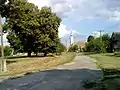 Blick auf die reformierte Kirche Rádfalva (erb. 1840)
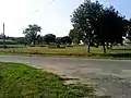 Hauptplatz (főtér)
Weblinks
Commons: Rádfalva – Sammlung von Bildern, Videos und Audiodateien
This article is issued from Wikipedia. The text is licensed under Creative Commons - Attribution - Sharealike. The authors of the article are listed here. Additional terms may apply for the media files, click on images to show image meta data.