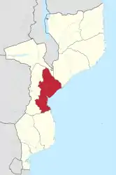
Provinz Sofala
Die Provinz Sofala liegt im Osten Mosambiks, auf dem Sofala-Schelf. Sie hat eine Fläche von 68.018 km². Auf dieser Fläche leben 2.221.803 Menschen.
| Sofala | |
|---|---|
 Lage | |
| Basisdaten | |
| Staat | Mosambik |
| Hauptstadt | Beira |
| Fläche | 68.018 km² |
| Einwohner | 2.221.803 (2017) |
| Dichte | 33 Einwohner pro km² |
| ISO 3166-2 | MZ-S |
Die Hauptstadt der Provinz Sofala ist die Stadt Beira. Sie hat 533.825 Einwohner.
Seit 1960 befindet sich in der Provinz Sofala der Nationalpark Gorongosa, der über einen einzigartigen Artenreichtum verfügt.
Es gibt in dieser Provinz in der Bucht gegenüber von Beira auch den Ort Sofala.
Administrative Gliederung
Die Provinz Sofala ist in zwölf Distrikte unterteilt:
Weblinks
Commons: Provinz Sofala – Sammlung von Bildern, Videos und Audiodateien
- Portal do Governo da Província de Sofala. auf www.sofala.gov.mz (portugiesisch)
- Ministério da Administração Estatal: Perfis dos Distritos. auf www.sofala.gov.mz (portugiesisch)
- Weiterführende Informationen. auf www.timeout.co.mz (englisch)
This article is issued from Wikipedia. The text is licensed under Creative Commons - Attribution - Sharealike. The authors of the article are listed here. Additional terms may apply for the media files, click on images to show image meta data.