Põhimaantee 9
Die Põhimaantee 9 (Nationalstraße 9) ist eine Fernstraße in Estland.
| Põhimaantee 9 in Estland | |
 | |
| Karte | |
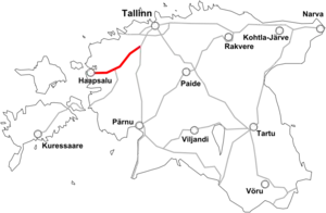
 Verlauf der M 9 | |
| Basisdaten | |
| Betreiber: | Maanteeamet |
| Straßenbeginn: | Ääsmäe (59° 14′ 28″ N, 24° 29′ 33″ O) |
| Straßenende: | Rohuküla (58° 54′ 28″ N, 23° 25′ 42″ O) |
| Gesamtlänge: | 80.9 km |
 | |
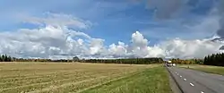
| Die Straße bei dem Dorf Kabila | |
Verlauf

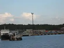
Der Hafen in Rohuküla (2009)
Die auch als Ääsmäe-Haapsalu-Rohuküla maantee bekannte Straße zweigt bei dem Dorf Ääsmäe von der Põhimaantee 4 (Europastraße 67) ab und führt über Risti (dort Abzweig der Põhimaantee 10) und Haapsalu zu dem Hafen Rohuküla, von dem aus Fähren zu den Inseln Hiiumaa (Dagö) und Vormsi verkehren.
Die Länge der Straße beträgt rund 81 km.
Geschichte
Während der Zugehörigkeit Estlands zur Sowjetunion trug die Straße die Bezeichnung A206.[1]
Einzelnachweise
- RV-Verlag: Euro-Regionalkarte 1:300.000 – Estland. 1993/1994. ISBN 3-575-11134-0.
Weblinks
Commons: Estonian national road 9 – Sammlung von Bildern, Videos und Audiodateien
Siehe auch
This article is issued from Wikipedia. The text is licensed under Creative Commons - Attribution - Sharealike. The authors of the article are listed here. Additional terms may apply for the media files, click on images to show image meta data.