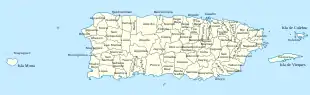
National Register of Historic Places in Puerto Rico
Das National Register of Historic Places in Puerto Rico ist Teil des nationalen Denkmalschutzprogramms der Vereinigten Staaten (Bauwerke, Objekte, Stätten und historische Distrikte).
Liste
Diese Liste enthält alle historischen Distrikte des National Register of Historic Places (NRHP).
Anzahl der Objekte und historischen Distrikte
 Faro de los Morrillos de Cabo Rojo in Cabo Rojo .jpg.webp) Convento de Porta Coeli in San Germán .jpg.webp) Catedral de Nuestra Señora de Guadalupe in Ponce |
|
 Centro ceremonial indígena de Caguana in Utuado  Fuerte de Vieques in Vieques  Hotel Normandie in San Juan 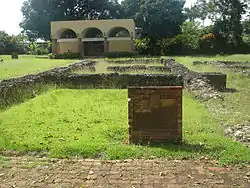 Caparra-Ruinen in Guaynabo | ||||||||||||||||||||||||||||||||||||||||||||||||||||||||||||||||||||||||||||||||||||||||||||||||||||||||||||||||||||||||||||||||||||||||||||||||||||||||||||||||||||||||||||||||||||||||||||||||||||||||||||||||||||||||||||||||||||||||||||||||||||||||||||||||||||||||||||||||||||||||||||||||||||||||||||||||||||||||||||||||
- Puente Arenas: Cayey und Cidra
- Puente La Liendre: Cayey und Cidra
- Puente Plata: Bayamón und Naranjito
- Puente de Añasco: Añasco und Mayagüez
- San Juan National Historic Site: San Juan und Toa Baja
- Puente Silva: Hormigueros und Cabo Rojo
Siehe auch
Weblinks
- (Seite nicht mehr abrufbar, Suche in Webarchiven: Puerto Rico State Historic Preservation Office) (spanisch)
- (Seite nicht mehr abrufbar, Suche in Webarchiven: National Park Service, National Register of Historic Places site)
Alabama | Alaska | Arizona | Arkansas | Colorado | Connecticut | Delaware | Florida | Georgia | Hawaii | Idaho | Illinois | Indiana | Iowa | Kalifornien | Kansas | Kentucky | Louisiana | Maine | Maryland | Massachusetts | Michigan | Minnesota | Mississippi | Missouri | Montana | Nebraska | Nevada | New Hampshire | New Jersey | New Mexico | New York (New York City) | North Carolina | North Dakota | Ohio | Oklahoma | Oregon | Pennsylvania | Rhode Island | South Carolina | South Dakota | Tennessee | Texas | Utah | Vermont | Virginia | Washington D.C. | Washington (Bundesstaat) | West Virginia | Wisconsin | Wyoming
Listen von Inselgebieten: Amerikanisch-Samoa | Guam | Minor Outlying Islands | Nördliche Marianen | Puerto Rico | Virgin Islands
Listen von assoziierten Staaten: Föderierte Staaten von Mikronesien | Marshallinseln | Palau
Andere Gebiete: District of Columbia | Tanger