Municipio Felipe Carrillo Puerto
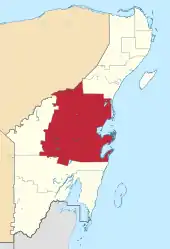
Felipe Carrillo Puerto ist ein Municipio im mexikanischen Bundesstaat Quintana Roo. Der Sitz der Gemeinde ist das gleichnamige Felipe Carrillo Puerto. Die Gemeinde hatte im Jahr 2020 83.990 Einwohner, ihre Fläche beträgt 12.983,3 km².[1]
| Felipe Carrillo Puerto | ||
|---|---|---|
 | ||
| Symbole | ||
| ||
| Basisdaten | ||
| Staat | Mexiko | |
| Bundesstaat | Quintana Roo | |
| Sitz | Felipe Carrillo Puerto | |
| Fläche | 12.983,3 km² | |
| Einwohner | 83.990 (2020) | |
| Dichte | 6,47 Einwohner pro km² | |
| Gründung | 1975 | |
| Webauftritt | www.felipecarrillopuerto.gob.mx/ | |
| INEGI-Nr. | 23002 | |
| Politik | ||
| Presidente municipal | José Esquivel Vargas | |
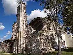 Die ehemalige Kathedrale von Tihosuco | ||
Geographie
Das Municipio Felipe Carrillo Puerto bildet das geographische Zentrum des Bundesstaates Quintana Roo. Es liegt zwischen Meereshöhe und 100 m Höhe in der physiographischen Provinz der Halbinsel Yucatán, zu 75 % in dessen Karstgebieten und zu 21 % in der Küstenregion Quintana Roos. Geologisch wird das Gemeindegebiet von Kalkstein dominiert, vorherrschender Bodentyp ist der Leptosol. Über 75 % des Municipios werden von Regenwäldern eingenommen.
Das Municipio Felipe Carrillo Puerto grenzt an die Municipios Solidaridad, José María Morelos und Bacalar sowie an den Bundesstaat Yucatán.
Orte
Das Municipio Felipe Carrillo Puerto umfasst laut Zensus 2020 178 bewohnte Orte, vom INEGI als urban klassifiziert sind der Hauptort Felipe Carrillo Puerto sowie Tihosuco, Chunhuhub, Señor und Tepich. Zwölf Orte wiesen beim Zensus 2020 eine Einwohnerzahl von über 1000 auf.[2]
| Ort | Einwohner[2] | Karte |
|---|---|---|
| Felipe Carrillo Puerto | 30.754 | 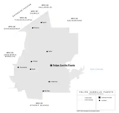 |
| Tihosuco | 5.228 | |
| Chunhuhub | 4.375 | |
| Señor | 3.785 | |
| Tepich | 3.585 | |
| Noh-Bec | 2.025 | |
| X-Hazil Sur | 1.388 | |
| X-Pichil | 1.227 | |
| Dzulá | 1.150 | |
| Polyuc | 1.148 | |
| Chun-Yah | 1100 | |
| Presidente Juárez | 1.034 |
Weblinks
- Enciclopedia de los Municipios y Delegaciones de México: Municipio Felipe Carrillo Puerto (spanisch)
- INEGI: Datos Geográficos: Municipio Felipe Carrillo Puerto (spanisch; PDF)
Einzelnachweise
- Panorama sociodemográfico de Quintana Roo. (PDF) INEGI, abgerufen am 11. April 2021 (spanisch).
- Censo de Poblacion y Vivienda 2020. (XLSX) INEGI, abgerufen am 11. April 2021 (spanisch).