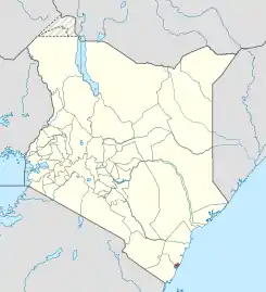
Mombasa County
Mombasa County (bis 2010 Mombasa District) ist ein County in Kenia. Es ist deckungsgleich mit der Stadt Mombasa und umfasst die vier Divisionen Changamwe, Mombasa Island, Kisauni und Likoni.[2]
| Mombasa County | |
|---|---|
| Einwohner (Stand) - Bevölkerungsdichte |
1.208.333 (2019) [1] 5686 Ew./km² |
| Fläche | 212,5 km² |
| Koordinaten | 4° 1′ S, 39° 39′ O |
| ISO 3166-2 | KE-28 |
 | |
Geographie
Das Mombasa County ist mit einer Gesamtfläche von 212,5 km² das kleinste County in Kenia und beinhaltet 65 km² Küstenmeer.[3]
| Division | Fläche in km² |
|---|---|
| Changamwe | 54,5 |
| Likoni | 51,3 |
| Kisauni | 109,7 |
| Mombasa Island | 14,1 |
| Gesamt | 229,6 |
Einzelnachweise
- 2019 Kenya Population and Housing Census Volume I: Population by County and Sub-County. KNBS, abgerufen am 20. November 2019 (englisch).
- Office for the Coordination of Humanitarian Affairs – Kenya AdminLevels 1-4 (.pdf, englisch)
- unep.org – Country-Profile Kenya (.doc, englisch; 949 kB)
Weblinks
Commons: Mombasa County – Sammlung von Bildern, Videos und Audiodateien
- Ministry of Public Works Kenya – Karte des Mombasa Distrikts (.pdf, englisch)
This article is issued from Wikipedia. The text is licensed under Creative Commons - Attribution - Sharealike. The authors of the article are listed here. Additional terms may apply for the media files, click on images to show image meta data.