Mikroregion Catalão
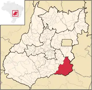
Die Mikroregion Catalão ist eine statistische Region des IBGE (Instituto Brasileiro de Geografia e Estatística) im Südosten des brasilianischen Bundesstaates Goiás. Sie gehört zur Mesoregion Süd-Goiás.
| Mikroregion Catalão | |
|---|---|
| Karte | |
 Lage der Mikroregion Catalão in Goiás | |
| Basisdaten | |
| Staat: | |
| Verwaltungsgliederung: | Mittelwesten |
| Bundesstaat: | |
| Mesoregion: | Süd-Goiás |
| Zeitzone: | UTC-3 Sommer: UTC-2 |
| Fläche: | 15.238,60 km² |
| Einwohner: | 147.191 IBGE: 2010[1] |
| Bevölkerungsdichte: | 9,7 Einwohner / km² |
| Anzahl der Gemeinden: | 11 |
Gemeinden in der Mikroregion Catalão
Eine Region mit hügliger wie auch flacher Landschaft mit extensiver Rinderzucht, Soja Plantagen und einem regionalen Zentrum in Catalão, das sehr schnell wächst.
| Gemeinde |
Fläche (km²) |
Einwohner (2010) |
BIP[2] 2006 (R$ 1.000,00) |
BIP pro Kopf[2] 2006 |
|---|---|---|---|---|
| Anhanguera | 57 | 1.017 | 5.950 | 6.510 |
| Campo Alegre de Goiás | 2.463 | 6.057 | 110.567 | 24.451 |
| Catalão | 3.778 | 86.597 | 2.488.759 | 34.720 |
| Corumbaíba | 1.482 | 8.164 | 177.466 | 23.703 |
| Cumari | 580 | 2.961 | 21.982 | 6.724 |
| Davinópolis | 520 | 2.050 | 14.912 | 7.349 |
| Goiandira | 561 | 5.268 | 32.081 | 6.868 |
| Ipameri | 4.369 | 24.745 | 257.489 | 10.736 |
| Nova Aurora | 303 | 2.069 | 12.891 | 6.485 |
| Ouvidor | 414 | 5.446 | 145.382 | 30.992 |
| Três Ranchos | 282 | 2.817 | 17.840 | 5.484 |
| Total: | 15.239 | 147.191 | 3.285.319 | 22.320 |
Siehe auch
Einzelnachweise
- Erste Ergebnisse der Volkszählung von 2010 in Goiás (PDF; 30 kB), (portugiesisch); abgerufen 20. Oktober 2011
- IBGE: Produto Interno Bruto a preços correntes e Produto Interno Bruto per capita, segundo as Grandes Regiões, Unidades da Federação e Municípios - 2003-2006 (Memento vom 6. März 2009 im Internet Archive), (port.), PDF-Datei; abgerufen 20. Oktober 2011
This article is issued from Wikipedia. The text is licensed under Creative Commons - Attribution - Sharealike. The authors of the article are listed here. Additional terms may apply for the media files, click on images to show image meta data.