Makemo (Gemeinde)
Makemo ist eine Gemeinde im Tuamotu-Archipel in Französisch-Polynesien.
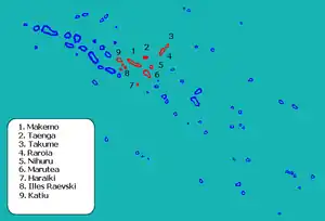
Die Gemeinde besteht aus 11 Atollen. Sie ist in 4 „Communes associées“ (Teilgemeinden) untergliedert. Der Hauptort der Gemeinde ist Makemo. Der Code INSEE der Gemeinde ist 98726.
![]() Karte mit allen Koordinaten: OSM | WikiMap
Karte mit allen Koordinaten: OSM | WikiMap
| Atoll oder Insel | Hauptort | Commune associée (Teilgemeinde) | Einwohner 2002 | Landfläche (km2) | Lagune (km2) | Post- leitzahl | Koordinaten |
|---|---|---|---|---|---|---|---|
| Makemo | Pouheua | Makemo | 745 | 56 | 854 | 98769 | 16° 36′ S, 143° 42′ W |
| Katiu | Hitianau | Katiu | 375 | 27 | 208 | 98790 | 16° 26′ S, 144° 22′ W |
| Raroia | Garumaoa | Raroia | 126 | 19,5 | 385 | 98790 | 16° 05′ S, 142° 25′ W |
| Taenga | Henuparea | Taenga | 100 | 20 | 140 | 98790 | 16° 21′ S, 143° 08′ W |
| Marutea Nord | – | Makemo | 0 | 2,7 | 458 | 17° 02′ S, 143° 10′ W | |
| Haraiki | – | Makemo | 0 | 4 | 10 | 17° 28′ S, 143° 27′ W | |
| Tuanake | – | Katiu | 0 | 6 | 26 | 16° 39′ S, 144° 13′ W | |
| Hiti | – | Katiu | 0 | 3 | 15 | 16° 44′ S, 144° 06′ W | |
| Tepoto Sud | – | Katiu | 0 | 0,6 | 2,5 | 16° 49′ S, 144° 17′ W | |
| Takume | Ohomo | Raroia | 93 | 5 | 43,5 | 98787 | 15° 48′ S, 142° 12′ W |
| Nihiru | Ototake | Taenga | 15 | 20 | 79 | 98790 | 16° 42′ S, 142° 50′ W |
| Gemeinde Makemo | Pouheua | 1454 | 164 | 2221 |

Position der Gemeinde Makemo
Die Gruppe der drei Atolle Tuanake, Hiti und Tepoto Sud wird auch „Raevski-Inseln“ (oder „Raevski-Atolle“) genannt.
This article is issued from Wikipedia. The text is licensed under Creative Commons - Attribution - Sharealike. The authors of the article are listed here. Additional terms may apply for the media files, click on images to show image meta data.