Louredo (Amarante)
Louredo ist eine Gemeinde im Nordwesten Portugals.
| Louredo | |||||
|---|---|---|---|---|---|
| |||||
| Basisdaten | |||||
| Region: | Norte | ||||
| Unterregion: | Tâmega e Sousa | ||||
| Distrikt: | Porto | ||||
| Concelho: | Amarante | ||||
| Koordinaten: | 41° 15′ N, 8° 7′ W | ||||
| Einwohner: | 638 (Stand: 30. Juni 2011)[1] | ||||
| Fläche: | 3,6 km² (Stand: 1. Januar 2010)[2] | ||||
| Bevölkerungsdichte: | 177 Einwohner pro km² | ||||
| Politik | |||||
| Adresse der Gemeindeverwaltung: | Junta de Freguesia de Louredo Lugar da Bouça da Cruz 4600 Amarante | ||||

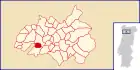
Louredo gehört zum Kreis Amarante im Distrikt Porto, besitzt eine Fläche von 3,6 km² und hat 638 Einwohner (Stand 30. Juni 2011)[1].
Einzelnachweise
- www.ine.pt – Indikator Resident population by Place of residence and Sex; Decennial in der Datenbank des Instituto Nacional de Estatística
- Übersicht über Code-Zuordnungen von Freguesias auf epp.eurostat.ec.europa.eu
Weblinks
- Karte der Freguesia Louredo beim Instituto Geográfico do Exército
- Information zu Louredo. amarante.pt, abgerufen am 12. Juni 2011 (portugiesisch).
Freguesias im Concelho Amarante
Aboadela, Sanche e Várzea | Amarante (São Gonçalo), Madalena, Cepelos e Gatão | Ansiães | Bustelo, Carneiro e Carvalho de Rei | Candemil | Figueiró (Santiago e Santa Cristina) | Fregim | Freixo de Cima e de Baixo | Fridão | Gondar | Jazente | Lomba | Louredo | Lufrei | Mancelos | Olo e Canadelo | Padronelo | Real, Ataíde e Oliveira | Rebordelo | Salvador do Monte | São Simão de Gouveia | Telões | Travanca | Vila Caiz | Vila Chã do Marão | Vila Garcia, Aboim e Chapa
This article is issued from Wikipedia. The text is licensed under Creative Commons - Attribution - Sharealike. The authors of the article are listed here. Additional terms may apply for the media files, click on images to show image meta data.