Lordelo (Guimarães)
Lordelo ist eine Kleinstadt (Vila) und Gemeinde in Portugal.
| Lordelo | ||||||
|---|---|---|---|---|---|---|
| ||||||
| Basisdaten | ||||||
| Region: | Norte | |||||
| Unterregion: | Ave | |||||
| Distrikt: | Braga | |||||
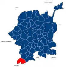
| Concelho: | Guimarães | |||||
| Koordinaten: | 41° 23′ N, 8° 23′ W | |||||
| Einwohner: | 4287 (Stand: 30. Juni 2011)[1] | |||||
| Fläche: | 4,97 km² (Stand: 1. Januar 2010)[2] | |||||
| Bevölkerungsdichte: | 863 Einwohner pro km² | |||||
| Postleitzahl: | 4815-131 | |||||
| Politik | ||||||
| Adresse der Gemeindeverwaltung: | Junta de Freguesia de Lordelo Av Prof. Luis Machado nº 502 Lordelo 4815-131 Lordelo | |||||
| Website: | www.jf-lordelo.pt | |||||

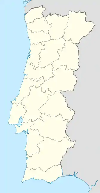
Lordelo gehört zum Kreis Guimarães im Distrikt Braga in der ehemaligen Provinz Minho. Sie besitzt eine Fläche von 5,0 km² und hat 4287 Einwohner (Stand 30. Juni 2011), womit sie zu den größten Gemeinden des Bezirks Guimarães gehört.
Einzelnachweise
- www.ine.pt – Indikator Resident population by Place of residence and Sex; Decennial in der Datenbank des Instituto Nacional de Estatística
- Übersicht über Code-Zuordnungen von Freguesias auf epp.eurostat.ec.europa.eu
Weblinks
- Karte der Freguesia Lordelo (Guimarães) beim Instituto Geográfico do Exército
- Página da Vila de Lordelo
Abação e Gémeos | Airão Santa Maria, Airão São João e Vermil | Aldão | Arosa e Castelões | Atães e Rendufe | Azurém | Barco | Briteiros Santo Estêvão e Donim | Briteiros São Salvador e Briteiros Santa Leocádia | Brito | Caldelas | Candoso São Tiago e Mascotelos | Conde e Gandarela | Costa | Creixomil | Fermentões | Gonça | Gondar | Guardizela | Infantas | Leitões, Oleiros e Figueiredo | Longos | Lordelo | Mesão Frio | Moreira de Cónegos | Nespereira | Oliveira, São Paio e São Sebastião | Pencelo | Pinheiro | Polvoreira | Ponte | Prazins Santo Tirso e Corvite | Ronfe | Sande São Lourenço e Balazar | Sande Vila Nova e Sande São Clemente | Santa Eufémia de Prazins | São Cristóvão de Selho | São João Baptista de Airão | São Jorge de Selho | São Martinho de Candoso | São Martinho de Sande | São Torcato | Selho São Lourenço e Gominhães | Serzedo e Calvos | Serzedo | Silvares | Souto Santa Maria, Souto São Salvador e Gondomar | Tabuadelo e São Faustino | Urgezes