Little Falls-South Windham
Little Falls-South Windham ist ein Census-designated place (CDP) im Cumberland County in Maine in den USA. Dort lebten 1.792 Menschen beim Zensus von 2000. Er ist Teil der Portland–South Portland–Biddeford Metropolitan Statistical Area.
| Little Falls-South Windham | |||
|---|---|---|---|
Lage in Maine | |||
| Basisdaten | |||
| Staat: | Vereinigte Staaten | ||
| Bundesstaat: | Maine | ||
| County: | Cumberland County | ||
| Koordinaten: | 43° 44′ N, 70° 25′ W | ||
| Zeitzone: | Eastern (UTC−5/−4) | ||
| Einwohner: – Metropolregion: | 1.792 (Stand: 2000) 513.102 (Stand: 1. Juli 2007) | ||
| Fläche: | 6,5 km² (ca. 3 mi²) davon 6,1 km² (ca. 2 mi²) Land | ||
| FIPS: | 23-40367 | ||
| GNIS-ID: | 2377928 | ||
Geografie
Nach dem United States Census Bureau hat der CDP eine Gesamtfläche von 6,5 km², von denen 6,1 km² Land und 0,3 km² (5,18 % der Gesamtfläche) Wasser sind.
Er ist zwischen den Orten Gorham (Little Falls) und Windham (South Windham) aufgeteilt und liegt am Presumpscot River.
| Citys | 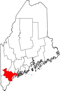 | |
| Towns |
Baldwin | Bridgton | Brunswick | Cape Elizabeth | Casco | Chebeague Island | Cumberland | Falmouth | Freeport | Frye Island | Gorham | Gray | Harpswell | Harrison | Long Island | Naples | New Gloucester | North Yarmouth | Pownal | Raymond | Scarborough | Sebago | Standish | Windham | Yarmouth | |
| CDPs |
Bridgton (CDP) | Brunswick (CDP) | Cumberland Center | Falmouth Foreside | Freeport (CDP) | Gorham (CDP) | Little Falls-South Windham | North Windham | Scarborough (CDP) | Yarmouth (CDP) | |
| unincorporated places |