Liste der Einträge im National Register of Historic Places im St. Francois County
Die Liste der Einträge im National Register of Historic Places im St. Francois County in Missouri führt die Bauwerke und historischen Stätten im St. Francois County auf, die in das National Register of Historic Places aufgenommen wurden.[1][2]
Legende
| NRHP | Historic Place |
|---|---|
| HD | Historic District |
Aktuelle Einträge
| [3] | Name[4] | Bild | Eintragsdatum | Lage | Ort | Beschreibung |
|---|---|---|---|---|---|---|
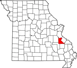
| 1 | Bonne Terre Depot | 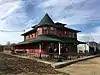 Bonne Terre Depot |
1984 ID-Nr. 84002606 |
Oak Street 37° 55′ 7″ N, 90° 32′ 56″ W |
Bonne Terre | |
| 2 | Bonne Terre Mine |  Bonne Terre Mine |
1974 ID-Nr. 74002281 |
MO 47 37° 55′ 22″ N, 90° 33′ 8″ W |
Bonne Terre | |
| 3 | Courthouse Square Historic District |  Courthouse Square Historic District |
2004 ID-Nr. 04000582 |
Abgegrenzt durch West Spring Street, North Washington Street, West Harrison Street und A Street 37° 46′ 51″ N, 90° 25′ 20″ W |
Farmington | |
| 4 | East Columbia Historic District | 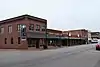 East Columbia Historic District |
2004 ID-Nr. 04000699 |
14–122, 101–103, 117–119, 202 East Columbia Street 37° 46′ 49″ N, 90° 25′ 11″ W |
Farmington | Der Distrikt wurde 2007 um das Gebäude 202 East Columbia Street erweitert |
| 5 | Eugene Field School | 2005 ID-Nr. 05000997 |
403 Glendale Street 37° 51′ 18″ N, 90° 31′ 9″ W |
Park Hills | ||
| 6 | Farmington State Hospital No. 4 Cemetery | 2010 ID-Nr. 08001360 |
Südlich der Doubet Road an der östlichen Seite der Pullan Road 37° 45′ 40″ N, 90° 26′ 28″ W |
Farmington | ||
| 7 | James Robinson McCormick House |  James Robinson McCormick House |
1998 ID-Nr. 98000945 |
324 West Columbia Street 37° 46′ 50″ N, 90° 25′ 33″ W |
Farmington | |
| 8 | Presbyterian Orphanage of Missouri |  Presbyterian Orphanage of Missouri |
2006 ID-Nr. 06000322 |
412 West Liberty Street 37° 47′ 0″ N, 90° 25′ 39″ W |
Farmington | |
| 9 | St. Francois County Jail and Sheriff’s Residence | 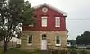 St. Francois County Jail and Sheriff’s Residence |
1996 ID-Nr. 96000764 |
11 North Franklin Street 37° 46′ 52″ N, 90° 25′ 23″ W |
Farmington | |
| 10 | St. Joe Lead Company Administration Building | 1984 ID-Nr. 84002611 |
Elm Street 37° 55′ 16″ N, 90° 32′ 59″ W |
Bonne Terre |
Siehe auch
Einzelnachweise
- Auszug aus dem National Register of Historic Places – St. Francois County Abgerufen am 5. Oktober 2012
- Missouri Department of National Resources – St. Francois County (Memento des Originals vom 26. Juni 2010 im Internet Archive) Info: Der Archivlink wurde automatisch eingesetzt und noch nicht geprüft. Bitte prüfe Original- und Archivlink gemäß Anleitung und entferne dann diesen Hinweis. Abgerufen am 5. Oktober 2012
- Die Nummerierung in dieser Listenspalte ist an der vom National Park Service vorgelegten Reihenfolge der Einträge orientiert; die Farben unterscheiden verschiedene Schutzgebietstypen des National Park Systems mit landesweiter Bedeutung (z. B. National Historic Landmarks) von den sonstigen Einträgen im National Register of Historic Places.
- National Register Information System. In: National Register of Historic Places. National Park Service. Abgerufen am 9. Juli 2010.
National Register of Historic Places in Missouri
Adair | Andrew | Atchison | Audrain | Barry | Barton | Bates | Benton | Bollinger | Boone | Buchanan | Butler | Caldwell | Callaway | Camden | Cape Girardeau | Carroll | Carter | Cass | Cedar | Chariton | Christian | Clark | Clay | Clinton | Cole | Cooper | Crawford | Dade | Dallas | Daviess | DeKalb | Dent | Douglas | Dunklin | Franklin | Gasconade | Gentry | Greene | Grundy | Harrison | Henry | Hickory | Holt | Howard | Howell | Iron | Jackson | Jasper | Jefferson | Johnson | Knox | Laclede | Lafayette | Lawrence | Lewis | Lincoln | Linn | Livingston | Macon | Madison | Maries | Marion | McDonald | Mercer | Miller | Mississippi | Moniteau | Monroe | Montgomery | Morgan | New Madrid | Newton | Nodaway | Oregon | Osage | Ozark | Pemiscot | Perry | Pettis | Phelps | Pike | Platte | Polk | Pulaski | Putnam | Ralls | Randolph | Ray | Reynolds | Ripley | Saline | Schuyler | Scotland | Scott | Shannon | Shelby | St. Charles | St. Clair | St. Francois | St. Louis | St. Louis City | Ste. Genevieve | Stoddard | Stone | Sullivan | Taney | Texas | Vernon | Warren | Washington | Wayne | Webster | Worth | Wright