Liste der Einträge im National Register of Historic Places im Chariton County
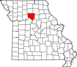
Die Liste der Einträge im National Register of Historic Places im Chariton County in Missouri führt die Bauwerke und historischen Stätten im Chariton County auf, die in das National Register of Historic Places aufgenommen wurden.[1][2]
Legende
| NRHP | Historic Place |
|---|---|
| HD | Historic District |
Aktuelle Einträge
| [3] | Name[4] | Bild | Eintragsdatum | Lage | Ort | Beschreibung |
|---|---|---|---|---|---|---|
| 1 | Chariton County Jail and Sheriff’s Residence |  Chariton County Jail and Sheriff’s Residence |
1997 ID-Nr. 96001597 |
305 South Cherry Street 39° 25′ 58″ N, 92° 56′ 30″ W |
Keytesville | |
| 2 | Dalton Vocational School Historic District | 2002 ID-Nr. 02000832 |
4th Street und MO J 39° 24′ 13″ N, 92° 59′ 36″ W |
Dalton | ||
| 3 | First Presbyterian Church | 112D78E2-56BA-4E5E-884C-FCA54E4BAB56.jpg.webp) First Presbyterian Church |
1977 ID-Nr. 77000802 |
Hill Street Ecke East Street 39° 26′ 9″ N, 92° 56′ 13″ W |
Keytesville | |
| 4 | Locust Hill | 1980 ID-Nr. 80002349 |
Östlich von Brunswick an der SR Y 39° 26′ 16″ N, 93° 6′ 37″ W |
Brunswick | ||
| 5 | Redding-Hill House |  Redding-Hill House |
1969 ID-Nr. 69000092 |
100 West North Street 39° 26′ 13″ N, 92° 56′ 12″ W |
Keytesville | |
| 6 | Salisbury Square Historic District | .jpg.webp) Salisbury Square Historic District |
2009 ID-Nr. 09000409 |
402, 404, 406, 407, 408, 502, 504, 506 und 508 South Broadway 39° 25′ 10,4″ N, 92° 48′ 6,1″ W |
Salisbury | |
| 7 | Fabrishous and Sarah A. Thomas House |  Fabrishous and Sarah A. Thomas House |
1999 ID-Nr. 99000744 |
302 East 2nd Street 39° 25′ 22″ N, 92° 47′ 53″ W |
Salisbury |
Siehe auch
Einzelnachweise
- Auszug aus dem National Register of Historic Places – Chariton County Abgerufen am 19. Oktober 2012
- Missouri Department of National Resources – Chariton County (Memento des Originals vom 21. Mai 2011 im Internet Archive) Info: Der Archivlink wurde automatisch eingesetzt und noch nicht geprüft. Bitte prüfe Original- und Archivlink gemäß Anleitung und entferne dann diesen Hinweis. Abgerufen am 19. Oktober 2012
- Die Nummerierung in dieser Listenspalte ist an der vom National Park Service vorgelegten Reihenfolge der Einträge orientiert; die Farben unterscheiden verschiedene Schutzgebietstypen des National Park Systems mit landesweiter Bedeutung (z. B. National Historic Landmarks) von den sonstigen Einträgen im National Register of Historic Places.
- National Register Information System. In: National Register of Historic Places. National Park Service. Abgerufen am 9. Juli 2010.
National Register of Historic Places in Missouri
Adair | Andrew | Atchison | Audrain | Barry | Barton | Bates | Benton | Bollinger | Boone | Buchanan | Butler | Caldwell | Callaway | Camden | Cape Girardeau | Carroll | Carter | Cass | Cedar | Chariton | Christian | Clark | Clay | Clinton | Cole | Cooper | Crawford | Dade | Dallas | Daviess | DeKalb | Dent | Douglas | Dunklin | Franklin | Gasconade | Gentry | Greene | Grundy | Harrison | Henry | Hickory | Holt | Howard | Howell | Iron | Jackson | Jasper | Jefferson | Johnson | Knox | Laclede | Lafayette | Lawrence | Lewis | Lincoln | Linn | Livingston | Macon | Madison | Maries | Marion | McDonald | Mercer | Miller | Mississippi | Moniteau | Monroe | Montgomery | Morgan | New Madrid | Newton | Nodaway | Oregon | Osage | Ozark | Pemiscot | Perry | Pettis | Phelps | Pike | Platte | Polk | Pulaski | Putnam | Ralls | Randolph | Ray | Reynolds | Ripley | Saline | Schuyler | Scotland | Scott | Shannon | Shelby | St. Charles | St. Clair | St. Francois | St. Louis | St. Louis City | Ste. Genevieve | Stoddard | Stone | Sullivan | Taney | Texas | Vernon | Warren | Washington | Wayne | Webster | Worth | Wright