Liste der Einträge im National Register of Historic Places im Moniteau County
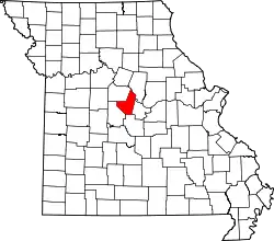
Die Liste der Einträge im National Register of Historic Places im Moniteau County in Missouri führt die Bauwerke und historischen Stätten im Moniteau County auf, die in das National Register of Historic Places aufgenommen wurden.[1][2]
Legende
| NRHP | Historic Place |
|---|---|
| HD | Historic District |
Aktuelle Einträge
| [3] | Name[4] | Bild | Eintragsdatum | Lage | Ort | Beschreibung |
|---|---|---|---|---|---|---|
| 1 | Louis Bruce Farmstead Historic District | 1992 ID-Nr. 91001916 |
Westlich von Russellville 38° 27′ 53″ N, 92° 31′ 7″ W |
Russellville | ||
| 2 | Finke Opera House | 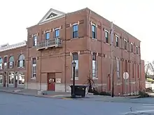 Finke Opera House |
2004 ID-Nr. 04000214 |
312 North High Street 38° 38′ 7″ N, 92° 33′ 55″ W |
California | |
| 3 | Geiger Archeological Site | 1969 ID-Nr. 69000114 |
Adresse nicht veröffentlicht |
Sandy Hook | ||
| 4 | Gray-Wood Buildings |  Gray-Wood Buildings |
1984 ID-Nr. 84002594 |
401–407 North High Street 38° 38′ 15″ N, 92° 33′ 55″ W |
California | |
| 5 | High Point Historic District | 2005 ID-Nr. 04001561 |
61235-61243 MO C 38° 29′ 4″ N, 92° 35′ 24″ W |
High Point | ||
| 6 | Maclay Mansion | 1979 ID-Nr. 79001383 |
209 West Howard Street 38° 39′ 35″ N, 92° 46′ 54″ W |
Tipton | ||
| 7 | Moniteau County Courthouse Square | 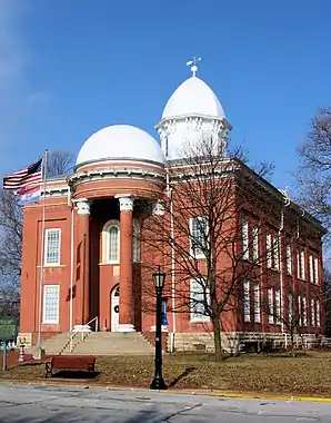 Moniteau County Courthouse Square |
1970 ID-Nr. 70000341 |
Public Square 38° 38′ 11″ N, 92° 33′ 53″ W |
California | |
| 8 | Old Barnhill Building | 1982 ID-Nr. 82003151 |
301 North High Street 38° 38′ 5″ N, 92° 33′ 56″ W |
California | ||
| 9 | Old California City Hall and Fire Station | 1982 ID-Nr. 82003152 |
101 North High Street 38° 37′ 58″ N, 92° 33′ 55″ W |
California |
Siehe auch
Einzelnachweise
- Auszug aus dem National Register of Historic Places – Moniteau County Abgerufen am 8. November 2012
- Department of National Resources – Moniteau County (Memento des Originals vom 21. Mai 2011 im Internet Archive) Info: Der Archivlink wurde automatisch eingesetzt und noch nicht geprüft. Bitte prüfe Original- und Archivlink gemäß Anleitung und entferne dann diesen Hinweis. Abgerufen am 8. November 2012
- Die Nummerierung in dieser Listenspalte ist an der vom National Park Service vorgelegten Reihenfolge der Einträge orientiert; die Farben unterscheiden verschiedene Schutzgebietstypen des National Park Systems mit landesweiter Bedeutung (z. B. National Historic Landmarks) von den sonstigen Einträgen im National Register of Historic Places.
- National Register Information System. In: National Register of Historic Places. National Park Service. Abgerufen am 9. Juli 2010.
National Register of Historic Places in Missouri
Adair | Andrew | Atchison | Audrain | Barry | Barton | Bates | Benton | Bollinger | Boone | Buchanan | Butler | Caldwell | Callaway | Camden | Cape Girardeau | Carroll | Carter | Cass | Cedar | Chariton | Christian | Clark | Clay | Clinton | Cole | Cooper | Crawford | Dade | Dallas | Daviess | DeKalb | Dent | Douglas | Dunklin | Franklin | Gasconade | Gentry | Greene | Grundy | Harrison | Henry | Hickory | Holt | Howard | Howell | Iron | Jackson | Jasper | Jefferson | Johnson | Knox | Laclede | Lafayette | Lawrence | Lewis | Lincoln | Linn | Livingston | Macon | Madison | Maries | Marion | McDonald | Mercer | Miller | Mississippi | Moniteau | Monroe | Montgomery | Morgan | New Madrid | Newton | Nodaway | Oregon | Osage | Ozark | Pemiscot | Perry | Pettis | Phelps | Pike | Platte | Polk | Pulaski | Putnam | Ralls | Randolph | Ray | Reynolds | Ripley | Saline | Schuyler | Scotland | Scott | Shannon | Shelby | St. Charles | St. Clair | St. Francois | St. Louis | St. Louis City | Ste. Genevieve | Stoddard | Stone | Sullivan | Taney | Texas | Vernon | Warren | Washington | Wayne | Webster | Worth | Wright