Lapu-Lapu City
Lapu-Lapu City ist eine philippinische Stadt (Component City) in der Provinz Cebu. Ihr früherer Name lautete Opon. Sie wurde zu Ehren des philippinischen Nationalhelden in Lapu-Lapu umbenannt und zu seinen Ehren wurde in der Stadt der Lapu-Lapu and Maghellan Shrine erbaut.
| Lapu-Lapu City (Opon) | |||
 Offizielles Siegel von Lapu-Lapu City | |||
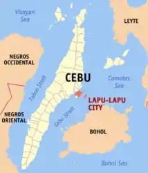
| Lage von Lapu-Lapu City in der Provinz Cebu | |||
|---|---|---|---|
 | |||
| Basisdaten | |||
| Region: | Central Visayas | ||
| Provinz: | Cebu | ||
| Barangays: | 30 | ||
| Distrikt: | 6. Distrikt von Cebu | ||
| PSGC: | 072226000 | ||
| Einkommensklasse: | 1. Einkommensklasse | ||
| Haushalte: | 44.439 Zensus 1. Mai 2000 | ||
| Einwohnerzahl: | 408.112 Zensus 1. August 2015 | ||
| Bevölkerungsdichte: | 6355 Einwohner je km² | ||
| Fläche: | 64,22 km² | ||
| Koordinaten: | 10° 18′ N, 124° 0′ O | ||
| Postleitzahl: | 6015 | ||
| Vorwahl: | +63 32 | ||
| Bürgermeister: | Junard A. Q. Chan | ||
| Website: | www.lapulapucity.gov.ph | ||
| Geographische Lage auf den Philippinen | |||
| |||

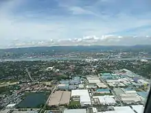
Die Stadt nimmt den größten Teil der Insel Mactan ein, die gerade einmal ein paar hundert Meter östlich der Insel Cebu liegt und mit ihr über zwei Brücken verbunden ist. Des Weiteren gehören Teile des Olango-Archipels, fünf Kilometer östlich der Insel Mactan, sowie ein paar weitere kleine Inseln zum Stadtgebiet. Die Gewässer um Lapu-Lapu City werden zum Danajon-Riffsystem im Süden der Camotes-See gezählt.
Lapu-Lapu City gehört zur Metropolregion Cebus Metro Cebu mit ihrem Zentrum Cebu City. Ihre Nachbargemeinden sind die Municipality of Cordova (Cebu) im Südwesten und Mandaue City im Norden auf der Insel Cebu gelegen. Lapu-Lapu City ist über zwei Brücken mit der Insel Cebu verbunden: der Mactan-Mandaue-Brücke und der Marcelo-Fernan-Brücke.
Das Gebiet der heutigen Stadt wurde bereits vor Ankunft spanischer Kolonisten Mactan genannt. Augustiner gründeten 1730 den Ort Opon, dieser Namen bestand bis zur Stadterhebung im Jahr 1961, als der Ort nach Lapu-Lapu umbenannt wurde.
Der Mactan-Cebu International Airport, zweitgrößter Flughafen der Philippinen, liegt in Lapu-Lapu City.
Barangays
Lapu-Lapu City ist politisch in 30 Barangays unterteilt.
|
|
Bedeutende Sehenswürdigkeiten und Einrichtungen
- Mactan Export Processing Zone (I & II)
- Cebu Light Industrial Park
- Marcelo Fernan Bridge Park
- Vaño Beach
- Plantation Bay Resort & Spa
- Maribago Blue Waters
- Waterfront Airport Hotel
- Shangri-La's Mactan Island Resort and Spa
- Cebu Hilton Resort and Towers
- Lapu-Lapu and Magellan Shrines
- SDR Serviced Apartments
- Marina Mall
- Mactan Coral Golf Club
- Cebu Yacht Club
- Scuba Diving off the Mactan Coast
Bildungseinrichtungen
- Campus der University of the Visayas