Kendriki Kerkyra ke Diapondia Nisia
Kendriki Kerkyra ke Diapondia Nisia (griechisch Κεντρική Κέρκυρα και Διαπόντια Νησιά) ist eine Gemeinde auf der griechischen Insel Korfu und den Diapontischen Inseln Erikoussa, Mathraki und Othoni in der Region Ionische Inseln. Sie wurde 2019 aus acht Gemeindebezirken der 2011 geschaffenen Gemeinde Kerkyra gebildet. Verwaltungssitz ist der Hauptort Korfu.
| Gemeinde Kendriki Kerkyra ke Diapondia Nisia Δήμος Κεντρικής Κέρκυρας και Διαποντίων Νήσων (Κεντρική Κέρκυρα και Διαπόντια Νησιά) | |||
|---|---|---|---|
| |||
| Basisdaten | |||
| Staat: | |||
| Region: | Ionische Inseln | ||
| Regionalbezirk: | Kerkyra | ||
| Geographische Koordinaten: | 39° 38′ N, 19° 49′ O | ||
| Fläche: | 259,504 km² | ||
| Einwohner: | 68.558 (2011[1]) | ||
| Bevölkerungsdichte: | 264,2 Ew./km² | ||
| Sitz: | Kerkyra | ||
| LAU-1-Code-Nr.: | 3201 | ||
| Gemeindebezirke: | 8 Gemeindebezirke | ||
| Lokale Selbstverwaltung: | 13 Stadtbezirke 33 Ortsgemeinschaften | ||
| Lage in der Region Ionische Inseln | |||
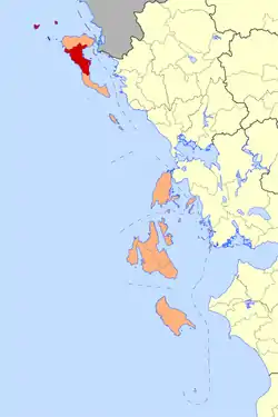 Datei:2019 Dimos Kendrikis Kerkyras.png | |||
Verwaltungsgliederung
Die Gemeinde Kendriki Kerkyra ke Diapondia Nisia besteht aus acht Gemeindebezirken[2] und ist weiter in 13 Stadtbezirke sowie 33 Ortsgemeinschaften untergliedert.
| Gemeindebezirke | griechischer Name | Code | Fläche (km²) | Einwohner 2011 | Stadtbezirke / Ortsgemeinschaften (Δημοτική /Τοπική Κοινότητα) |
Lage |
|---|---|---|---|---|---|---|
| Achillio | Δημοτική Ενότητα Αχιλλείων | 320103 | 48,312 | 10.651 | Gastouri, Agios Prokopios, Agii Deka, Ano Garouna, Varypatades, Viros, Kalafationes, Kamara, Kastellani Mesi, Kato Garouna, Kouramades, Kynopiastes, Benitses, Stavros | 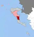 |
| Erikoussa | Δημοτική Ενότητα Ερεικούσσης | 320104 | 4,354 | 496 | Errikousa |  |
| Feakes | Δημοτική Ενότητα Φαιάκων | 320115 | 54,564 | 6545 | Kato Korakiana, Agios Markos, Ano Korakiana, Zygos, Sgourades, Spartylas, Sokraki | 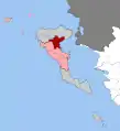 |
| Kerkyra | Δημοτική Ενότητα Κερκυραίων | 320101 | 41,341 | 39.674 | Korfu, Alepou, Evropouli, Kanali | 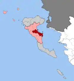 |
| Mathraki | Δημοτική Ενότητα Μαθρακίου | 320110 | 3,497 | 329 | Mathraki, mit den unbewohnten Inseln Diakopo, Diaplo, Platia, Trachia, Psyllos ena |  |
| Othoni | Δημοτική Ενότητα Οθωνών | 320112 | 10,502 | 392 | Othoni |  |
| Paleokastritsa | Δημοτική Ενότητα Παλαιοκαστριτών | 320113 | 48,422 | 4068 | Lakones, Alimmatades, Gardelades, Doukades, Krini, Liapades, Makrades, Skripero | 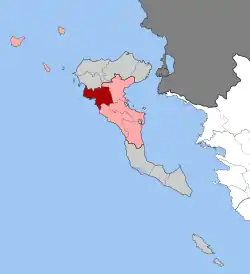 |
| Parelii | Δημοτική Ενότητα Παρελίων | 320114 | 48,512 | 6403 | Kokkini, Agios Ioannis, Afra, Vatos, Giannades, Kanakades, Kombitsi, Marmaro, Pelekas, Sinarades | 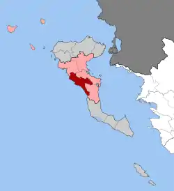 |
| Gesamt | 3201 | 259,504 | 68.558 | |||
Einzelnachweise
- Ergebnisse der Volkszählung 2011 beim Nationalen Statistischen Dienst Griechenlands (ΕΛ.ΣΤΑΤ) (Excel-Dokument, 2,6 MB)
- Gesetz 4600, Griechisches Gesetzesblatt vom 9. März 2019 (ΦΕΚ Α43/09.03.2019, Άρθρο 154, Τροποποίηση του άρθρου 1 του ν. 3852/2010), S. 1164. PDF Online (griechisch)
This article is issued from Wikipedia. The text is licensed under Creative Commons - Attribution - Sharealike. The authors of the article are listed here. Additional terms may apply for the media files, click on images to show image meta data.