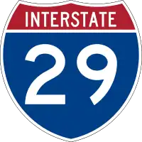
Interstate 29
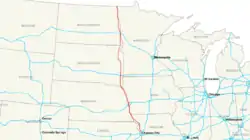
Die Interstate 29 (kurz I-29) ist ein Interstate Highway im Mittleren Westen der Vereinigten Staaten. Sie beginnt an der Interstate 35 in Kansas City und endet an der kanadischen Grenze, wonach sie zur Manitoba Provincial Highway 75 wird.
 Interstate 29 | ||||||||||||||||||||||||||||||||||
| Basisdaten | ||||||||||||||||||||||||||||||||||
|---|---|---|---|---|---|---|---|---|---|---|---|---|---|---|---|---|---|---|---|---|---|---|---|---|---|---|---|---|---|---|---|---|---|---|
| Länge: | 755 mi/1215 km | |||||||||||||||||||||||||||||||||
| Bundesstaaten: | Missouri Iowa South Dakota North Dakota | |||||||||||||||||||||||||||||||||
| Karte | ||||||||||||||||||||||||||||||||||
 | ||||||||||||||||||||||||||||||||||
|
Verlauf
| ||||||||||||||||||||||||||||||||||
Längen
| Meilen | km | Staat | |
| 123 | 198 | Missouri | |
| 161 | 259 | Iowa | |
| 252 | 406 | South Dakota | |
| 217 | 349 | North Dakota | |
| 753 | 1212 | Total | |
Wichtige Städte
- Kansas City (Missouri)
- St. Joseph (Missouri)
- Mound City (Missouri)
- Council Bluffs (Iowa)
- Sioux City (Iowa)
- Sioux Falls (South Dakota)
- Fargo (North Dakota)
- Grand Forks (North Dakota)
Zubringer und Umgehungen
- Interstate 229 bei St. Joseph
- Interstate 129 bei Sioux City
- Interstate 229 bei Sioux Falls
Weblinks
| Main Interstates |
2 • 4 • 5 • 8 • 10 • 11 • 12 • 14 • 15 • 16 • 17 • 19 • 20 • 22 • 24 • 25 • 26 • 27 • 29 • 30 • 35 • 37 • 39 • 40 • 41 • 43 • 44 • 45 • 49 • 55 • 57 • 59 • 64 • 65 • 66 • 68 • 69 • 70 • 71 • 72 • 73 • 74 • 75 • 76 (West) • 76 (Ost) • 77 • 78 • 79 • 80 • 81 • 82 • 83 • 84 (West) • 84 (Ost) • 85 • 86 (West) • 86 (Ost) • 87 (Nord) • 87 (Süd) • 88 (West) • 88 (Ost) • 89 • 90 • 91 • 93 • 94 • 95 • 96 • 97 • 99 • 238 |
 |
|---|---|---|
| Hawaii | ||
| Alaska |
A-1 • A-2 • A-3 • A-4 | |
| Puerto Rico |
PR-1 • PR-2 • PR-3 |