Ilhas de Sotavento
Die Ilhas de Sotavento (deutsch: „Inseln unter dem Winde“) sind eine der Inselgruppen der Kapverdischen Inseln.
| Ilhas de Sotavento | |
|---|---|
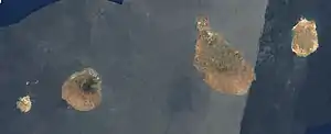 Satellitenbild | |
| Gewässer | Atlantischer Ozean |
| Archipel | Kapverdische Inseln |
| Geographische Lage | 15° 0′ N, 24° 0′ W |
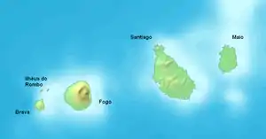
 Karte von Ilhas de Sotavento | |
| Anzahl der Inseln | 9 |
| Hauptinsel | Santiago |
| Gesamte Landfläche | 1804 km² |
| Einwohner | 343.300 |
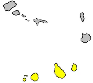
 Lage der Inselgruppe | |
Zur Gruppe zählen folgende Inseln:
| Insel | Koordinate | Fläche km² |
Einwohner |
|---|---|---|---|
| Maio | 15° 13′ N, 23° 10′ W | 269 | 8.400 |
| Santiago | 15° 5′ N, 23° 37′ W | 991 | 290.000 |
| Fogo | 14° 57′ N, 24° 23′ W | 476 | 38.600 |
| Brava | 14° 51′ N, 24° 42′ W | 67 | 6.300 |
| Ilhéus do Rombo | 14° 58′ N, 24° 41′ W | 4 | 0 |
This article is issued from Wikipedia. The text is licensed under Creative Commons - Attribution - Sharealike. The authors of the article are listed here. Additional terms may apply for the media files, click on images to show image meta data.