Ilhas de Barlavento
Die Ilhas de Barlavento (deutsch: „Inseln über dem Winde“) sind eine Inselgruppe im Archipel der Kapverdischen Inseln.
| Ilhas de Barlavento | |
|---|---|
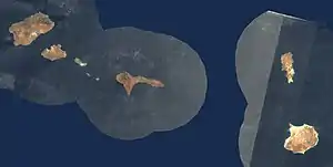 Satellitenbild | |
| Gewässer | Atlantischer Ozean |
| Archipel | Kapverdische Inseln |
| Geographische Lage | 16° 40′ N, 24° 0′ W |
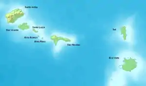
 Karte von Ilhas de Barlavento | |
| Anzahl der Inseln | 9 |
| Hauptinsel | Sal |
| Gesamte Landfläche | 2230 km² |
| Einwohner | 172.500 |
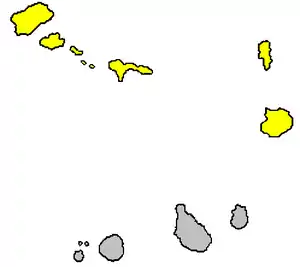
 Lage der Inselgruppe | |
Zur Inselgruppe zählen:
| Insel | Koordinate | Fläche km² |
Einwohner |
|---|---|---|---|
| Santo Antão | 17° 4′ N, 25° 10′ W | 779 | 47.100 |
| São Vicente | 16° 51′ N, 24° 58′ W | 227 | 83.000 |
| Santa Luzia | 16° 46′ N, 24° 45′ W | 34 | 0 |
| São Nicolau | 16° 37′ N, 24° 16′ W | 388 | 12.700 |
| Sal | 16° 44′ N, 22° 56′ W | 216 | 25.000 |
| Boa Vista | 16° 6′ N, 22° 49′ W | 620 | 4.700 |
| Branco | 16° 39′ N, 24° 41′ W | 3 | 0 |
| Raso | 16° 37′ N, 24° 36′ W | 7 | 0 |
| dos Pássaros | 16° 55′ N, 25° 1′ W | 0,023 | 0 |
This article is issued from Wikipedia. The text is licensed under Creative Commons - Attribution - Sharealike. The authors of the article are listed here. Additional terms may apply for the media files, click on images to show image meta data.