Hoye-Crest
Der Hoye Crest ist mit seinen 1020 Metern der höchste Berg des Garrett County und des US-Bundesstaates Maryland. Der Berg befindet sich unweit der Grenze zu West Virginia. Auf seinem Gipfel steht eine Markierungstafel, welche genaue Informationen über die Erhebung gibt.
| Hoye-Crest | ||
|---|---|---|
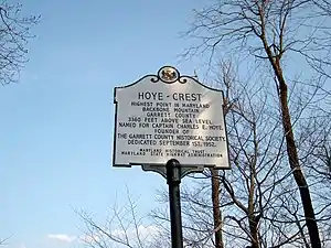
Das Gipfelkreuz am Hoye-Crest | ||
| Höhe | 1020 m | |
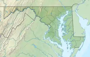
| Lage | Garrett County, Maryland | |
| Gebirge | Backbone Mountain, Allegheny Mountains | |
| Koordinaten | 39° 14′ 14″ N, 79° 29′ 9″ W | |
| ||
Weblinks
- Hoye-Crest auf Peakbagger.com (englisch)
- https://www.summitpost.org/backbone-mountain/152048

Alabama | Alaska | Arizona | Arkansas | Colorado | Connecticut | Delaware | Florida | Georgia | Hawaii | Idaho | Illinois | Indiana | Iowa | Kalifornien | Kansas | Kentucky | Louisiana | Maine | Maryland | Massachusetts | Michigan | Minnesota | Mississippi | Missouri | Montana | Nebraska | Nevada | New Hampshire | New Jersey | New Mexico | New York | North Carolina | North Dakota | Ohio | Oklahoma | Oregon | Pennsylvania | Rhode Island | South Carolina | South Dakota | Tennessee | Texas | Utah | Vermont | Virginia | Washington | West Virginia | Wisconsin | Wyoming
Inselgebiete: Amerikanisch-Samoa | Guam | Minor Outlying Islands | Nördliche Marianen | Puerto Rico | Virgin Islands
Andere Gebiete: District of Columbia