Hitra cesta H4
Die Hitra cesta H4 (slowenisch für ,Schnellstraße H4‘) verläuft vom Knoten Razdrto an der A1 bis an die italienische Grenze bei Vrtojba. Mit dem Bau wurde 1990 begonnen, die vollständige Eröffnung fand im August 2009 statt. Sie ist 40,9 km lang und verbindet Nova Gorica mit Ljubljana.
| Hitra cesta H4 in Slowenien | ||||||||||||||||||||||||||||||||||||||||||||||||||||||||||||||||||||||||||||||||||||||||
 | ||||||||||||||||||||||||||||||||||||||||||||||||||||||||||||||||||||||||||||||||||||||||
| Karte | ||||||||||||||||||||||||||||||||||||||||||||||||||||||||||||||||||||||||||||||||||||||||
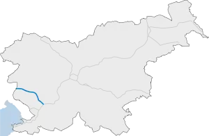 Verlauf der H 4 | ||||||||||||||||||||||||||||||||||||||||||||||||||||||||||||||||||||||||||||||||||||||||
| In Betrieb | ||||||||||||||||||||||||||||||||||||||||||||||||||||||||||||||||||||||||||||||||||||||||
| Basisdaten | ||||||||||||||||||||||||||||||||||||||||||||||||||||||||||||||||||||||||||||||||||||||||
| Betreiber: | DARS | |||||||||||||||||||||||||||||||||||||||||||||||||||||||||||||||||||||||||||||||||||||||
| davon in Betrieb: | 40,9 km | |||||||||||||||||||||||||||||||||||||||||||||||||||||||||||||||||||||||||||||||||||||||
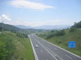 | ||||||||||||||||||||||||||||||||||||||||||||||||||||||||||||||||||||||||||||||||||||||||
| Die H4 kurz nach der Grenze bei Nova Gorica | ||||||||||||||||||||||||||||||||||||||||||||||||||||||||||||||||||||||||||||||||||||||||
Straßenverlauf
| ||||||||||||||||||||||||||||||||||||||||||||||||||||||||||||||||||||||||||||||||||||||||
Betrieben wird die Schnellstraße von der slowenischen Autobahngesellschaft DARS.
Weblinks
Commons: H4 – Sammlung von Bildern, Videos und Audiodateien
- H4 Razdrto - Vrtojba. DARS: O avtocestah > Nacionalni program izgradnje avtocest. (Baubeschreibungen der einzelnen Etappen).
- Die H4 bei motorways-exitlists.com
This article is issued from Wikipedia. The text is licensed under Creative Commons - Attribution - Sharealike. The authors of the article are listed here. Additional terms may apply for the media files, click on images to show image meta data.