Guadalupe (Arizona)
Guadalupe ist eine Kleinstadt im Maricopa County im US-Bundesstaat Arizona. Sie hat 5228 Einwohner auf einer Fläche von 2,0 km². Guadalupe liegt an der Interstate 10.
| Guadalupe | |
|---|---|
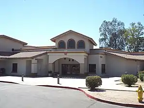 Guadalupe City Hall (Rathaus) | |
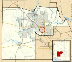
| Lage im Maricopa County und in Arizona | |
 | |
| Basisdaten | |
| Gründung: | 1900 |
| Staat: | Vereinigte Staaten |
| Bundesstaat: | Arizona |
| County: | Maricopa County |
| Koordinaten: | 33° 22′ N, 111° 58′ W |
| Zeitzone: | Mountain Standard Time (UTC−7) |
| Einwohner: | 5.322 (Stand: 2020) |
| Fläche: | 2,0 km² (ca. 1 mi²) davon 2,0 km² (ca. 1 mi²) Land |
| Höhe: | 376 m |
| Postleitzahl: | 85283 |
| Vorwahl: | +1 480 |
| FIPS: | 04-30270 |
| GNIS-ID: | 0005415 |
| Website: | www.guadalupeaz.org |
| Bürgermeister: | Rebecca Jimenez |
Weblinks
| Stadt |
Avondale | Buckeye | Chandler | El Mirage | Glendale | Goodyear | Litchfield Park | Mesa | Peoria | Phoenix | Scottsdale | Surprise | Tempe | Tolleson |
 |
| Towns |
Carefree | Cave Creek | Fountain Hills | Gila Bend | Gilbert | Guadalupe | Paradise Valley | Queen Creek | Wickenburg | Youngtown | |
| Census-designated places (CDP) |
Aguila | Anthem | Arlington | Citrus Park | Gila Crossing | Kaka | Komatke | Maricopa Colony | Morristown | New River | Rio Verde | St. Johns | Sun City | Sun City West | Sun Lakes | Theba | Tonopah | Wintersburg | Wittmann | |
| Weitere Siedlungen |
Agua Fria | Apache Wells | Arrowhead Ranch | Beardsley | Big Horn | Bosque | Camel | Camp Creek | Chandler Heights |‡ Chiulikam | Circle City | Co-op Village | Cotton Center | Crag | Desert Hills | Dixie | Dreamland Villa | Forepaugh | Fort McDowell | Freeman | Germann | Gillespie | Gladden | Harqua | Higley | Laveen | Leisure World | Liberty | Lone Butte Ranch | Lone Mountain Ranch | Maricopa Village | Matthie | Midway | Mobile | Moivayi | Montezuma | Palo Verde | Papago | Piedra | Point of Rocks | Rainbow Valley | Rocky Point | Saddle | Salt River | San Lucy Village | Santa Maria | Sentinel | Serape | Smurr | Stanwix | Sundad | Sunflower | Sunnyslope | Tartron | Tortilla Flat | Totopitk | Troon | Waddell | Webb | Weedville | |
| Indianerreservat |
Gila River Indian Reservation | Salt River Pima–Maricopa Indian Community | Fort McDowell Yavapai Nation | Tohono O’odham Nation Reservation | |
| Geisterstadt |
Agua Caliente | Allenville | Cashion | Lizard Acres | Marinette | Vulture City |