Gorakhpur (Division)
Die Division Gorakhpur ist eine Division im indischen Bundesstaat Uttar Pradesh. Der Verwaltungssitz befindet sich in der Stadt Gorakhpur.
| Gorakhpur Division | |
|---|---|
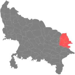 Lagekarte der Division | |
| Bundesstaat: | Uttar Pradesh |
| Koordinaten | 26° 45′ N, 83° 22′ O |
| Verwaltungssitz: | Gorakhpur |
| Fläche: | 11.718 km² |
| Einwohner: | 13.791.088 |
| Bevölkerungsdichte: | 1.177 Einwohner/km² |
| Distrikte: | 4 |
Distrikte
Die Division Gorakhpur gliedert sich in vier Distrikte:[1][2]
| Distrikt | Verwaltungssitz | Fläche in km² | Einwohner (2011) | Ew./km² |
|---|---|---|---|---|
| Gorakhpur | Gorakhpur | 3.321 | 4.440.895 | 1.377 |
| Kushinagar | Kushinagar | 2.905 | 3.564.544 | 1.227 |
| Deoria | Deoria | 2.540 | 3.100.946 | 1.221 |
| Maharajganj | Maharajganj | 2.952 | 2.684.703 | 909 |
Einzelnachweise
- Divisions of Uttar Pradesh Administrative Divisions of Uttar Pradesh In Uttar Pradesh, there are 18 Divisions , 72 districts, 821 blocks, 52021 Panchayat and 107452 villages. BrandBharat.com. Abgerufen am 11. August 2019.
- Indian Districts by Population, Sex Ratio, Literacy 2011 Census. Abgerufen am 11. August 2019.
This article is issued from Wikipedia. The text is licensed under Creative Commons - Attribution - Sharealike. The authors of the article are listed here. Additional terms may apply for the media files, click on images to show image meta data.