Chincoteague (Virginia)
Chincoteague (IPA: /ˌʃɪŋkəˈtiːɡ/ oder /ˈʃɪŋkətiːɡ/) ist eine US-amerikanische Kleinstadt auf der Insel Chincoteague Island im Landkreis Accomack County, Virginia auf der Delmarva-Halbinsel. Chincoteague ist ein Lehnwort aus den Algonkin-Sprachen.
| Chincoteague | |||
|---|---|---|---|
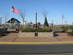
 Statue von Misty of Chincoteague | |||
_01.png.webp) Siegel |
|||
| Lage in Virginia | |||
| |||
| Basisdaten | |||
| Gründung: | 1908 | ||
| Staat: | Vereinigte Staaten | ||
| Bundesstaat: | Virginia | ||
| County: | Accomack County | ||
| Koordinaten: | 37° 56′ N, 75° 22′ W | ||
| Zeitzone: | Eastern (UTC−5/−4) | ||
| Einwohner: | 2.941 (Stand: 2010) | ||
| Fläche: | 96 km² (ca. 37 mi²) davon 71,1 km² (ca. 27 mi²) Land | ||
| Höhe: | 1 m | ||
| Postleitzahl: | 23336 | ||
| Vorwahl: | +1 757 | ||
| FIPS: | 51-16512 | ||
| GNIS-ID: | 2390792 | ||
| Website: | www.chincoteague-va.gov | ||
| Bürgermeister: | John H. Tarr | ||
 Statue eines Chincoteague Ponys an der Hauptstraße | |||
Die Einwohnerzahl betrug im Jahr 2010 2941. Die Fläche der Ortschaft beträgt 96,0 km². Nach dem Ort sind die Assateague-Ponys (Chincoteague Ponys) benannt, die auf Assateague Island leben. Die Insel Chincoteague Island hat eine Fläche von 55,4 km².
Nahe der Stadt befand sich die Naval Auxiliary Air Station (NAAS) Chincoteague, Teil davon war die Naval Aviation Ordnance Test Station (NAOTS), auf der verschiedene Waffensysteme und Raketen entwickelt und getestet wurden.
Weblinks
Commons: Chincoteague Island (Virginia) – Sammlung von Bildern, Videos und Audiodateien
This article is issued from Wikipedia. The text is licensed under Creative Commons - Attribution - Sharealike. The authors of the article are listed here. Additional terms may apply for the media files, click on images to show image meta data.
